Tyup geodata
Tyup (Issyk-Kul) is a seat of a second-order administrative division; located in Kyrgyzstan in Asia/Bishkek (GMT+6) time zone. With population of 13,437 people, there are 25 cities with bigger population in this country. Compared to other cities in Kyrgyzstan, 85.7% of cities are located further ↓South; 97.6% of cities are located further ←West and 78.6% of cities have lower elevation than Tyup. Note1


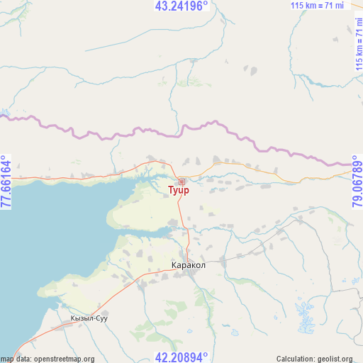
Tyup GPS coordinates[2]
42° 43' 39.36" North, 78° 21' 53.136" East
| Map corner | latitude | longitude |
|---|---|---|
| Upper-left | 43.24196°, | 77.66164° |
| Center: | 42.7276°, | 78.36476° |
| Lower-right: | 42.20894°, | 79.06789° |
| Map W x H: | 114.9×114.9 km | = 71.4×71.4mi |
| max Lat: | 42.89106° ⇑14.3% North |
| Tyup: | 42.7276° |
| min Lat: | ⇓85.7% South 39.55274° |
| min Long | Tyup | max Long |
| 69.3716° | 78.36476° | 78.52702° |
| W 97.6%⇐ | ⇒2.4% E |
Elevation
Elevation of Tyup is 1629 m = 5344 ft, and this is 427.6 m = 1403 ft above average elevation for this country.
| Max E: |
2638 m = 8655 ft | 21.4% |
| Tyup | 1629 m 5344 ft | |
| Avg. | 1201.4 m = 3942 ft | |
Min E: |
504 m = 1654 ft | 78.6% |
See also: Kyrgyzstan elevation on elevation.city.
Geographical zone
Tyup is located in North temperate zone (between Tropic of Cancer and the Arctic Circle). Distance of this Northern Tropic circle is 2144.9 km =1332.8 mi to South.| Distance of | km | miles | from Tyup |
|---|---|---|---|
| North Pole | 5256.2 | 3266.1 | to North |
| Arctic Circle | 2650.3 | 1646.8 | to North |
| Tropic Cancer | 2144.9 | 1332.8 | to South |
| Equator | 4750.9 | 2952.1 | to South |


Nearby cities:
15 places around Tyup: (largest is in red/bold)
• Ak-Suu
28.6 km =17.8 mi,  152°
152°
• At-Bashi
273.8 km =170.1 mi,  230°
230°
• Balykchy
180.7 km =112.3 mi,  260°
260°
• Bokombayevskoye
131.4 km =81.6 mi,  238°
238°
• Cholpon-Ata
105.2 km =65.4 mi,  265°
265°
• Chuy
251.8 km =156.5 mi, 272°
• Ivanovka
268.1 km =166.6 mi, 273°
• Kadzhi-Say
117.2 km =72.8 mi, 236°
• Karakol
26.4 km =16.4 mi,  174°
174°
• Kemin
218.3 km =135.6 mi, 271°
• Kochkor
221.3 km =137.5 mi, 255°
• Kyzyl-Suu
52 km =32.3 mi,  214°
214°
• Naryn
243.4 km =151.2 mi, 233°
• Tokmok
250.3 km =155.5 mi, 272°
• Tossor
98 km =60.9 mi, 230°
Sources, notices
• [Note1] Compared only with cities in Kyrgyzstan existing in our database
• [Src1] Map data: © OpenStreetMap contributors (CC-BY-SA)
• [Src2] Other city data from geonames.org with taken over terms of usage.
• [Src3] Geographical zone / Annual Mean Temperature by Robert A. Rohde @ Wikipedia
