Urzhar geodata
Urzhar (East Kazakhstan) is a populated place; located in Kazakhstan in Asia/Almaty (GMT+5) time zone. With population of 14,826 people, there are 78 cities with bigger population in this country. Compared to other cities in Kazakhstan, 61.1% of cities are located further ↑North; 92.2% of cities are located further ←West and 71.9% of cities have lower elevation than Urzhar. Note1


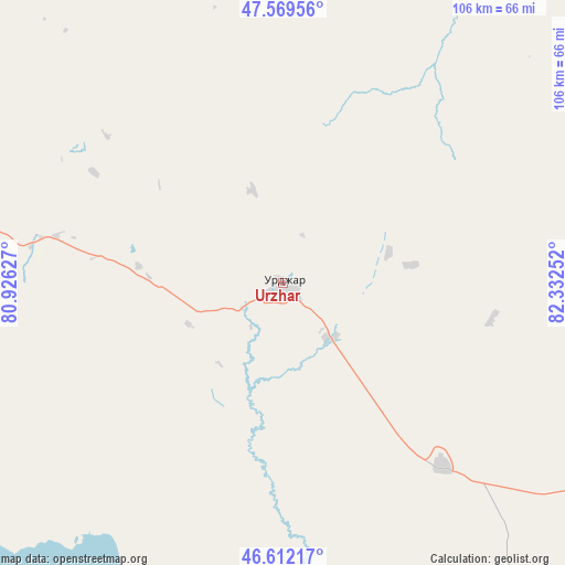
Urzhar GPS coordinates[2]
47° 5' 34.872" North, 81° 37' 45.804" East
| Map corner | latitude | longitude |
|---|---|---|
| Upper-left | 47.56956°, | 80.92627° |
| Center: | 47.09302°, | 81.62939° |
| Lower-right: | 46.61217°, | 82.33252° |
| Map W x H: | 106.5×106.5 km | = 66.2×66.2mi |
| max Lat: | 54.90596° ⇑61.1% North |
| Urzhar: | 47.09302° |
| min Lat: | ⇓38.9% South 40.66338° |
| min Long | Urzhar | max Long |
| 46.83361° | 81.62939° | 84.87144° |
| W 92.2%⇐ | ⇒7.8% E |
Elevation
Elevation of Urzhar is 479 m = 1572 ft, and this is 122.5 m = 402 ft above average elevation for this country.
| Max E: |
1847 m = 6060 ft | 28.1% |
| Urzhar | 479 m 1572 ft | |
| Avg. | 356.5 m = 1170 ft | |
Min E: |
-26 m = -85 ft | 71.9% |
See also: Kazakhstan elevation on elevation.city.
Geographical zone
Urzhar is located in North temperate zone (between Tropic of Cancer and the Arctic Circle). Distance of this North polar circle is 2164.9 km =1345.2 mi to North.| Distance of | km | miles | from Urzhar |
|---|---|---|---|
| North Pole | 4770.8 | 2964.4 | to North |
| Arctic Circle | 2164.9 | 1345.2 | to North |
| Tropic Cancer | 2630.3 | 1634.4 | to South |
| Equator | 5236.3 | 3253.7 | to South |


Nearby cities:
15 places around Urzhar: (largest is in red/bold)
• Aksuat
237.5 km =147.6 mi,  40°
40°
• Aqtoghay
149.6 km =93 mi,  263°
263°
• Ayagoz
132.1 km =82.1 mi,  317°
317°
• Druzhba
214.8 km =133.5 mi,  162°
162°
• Georgīevka
248.4 km =154.3 mi,  359°
359°
• Kokpekty
193 km =119.9 mi,  17°
17°
• Kurchum
223.2 km =138.7 mi, 42°
• Lepsy
225.9 km =140.4 mi,  245°
245°
• Matay
259.6 km =161.3 mi,  239°
239°
• Priisk Boko
218.7 km =135.9 mi,  0°
0°
• Sarkand
228.7 km =142.1 mi,  215°
215°
• Sarykamys
232.1 km =144.2 mi,  289°
289°
• Tūghyl
206.2 km =128.1 mi,  70°
70°
• Zaysan
248 km =154.1 mi,  80°
80°
• Zhalghyztobe
237.5 km =147.6 mi,  352°
352°
Sources, notices
• [Note1] Compared only with cities in Kazakhstan existing in our database
• [Src1] Map data: © OpenStreetMap contributors (CC-BY-SA)
• [Src2] Other city data from geonames.org with taken over terms of usage.
• [Src3] Geographical zone / Annual Mean Temperature by Robert A. Rohde @ Wikipedia
