Matay geodata
Matay (Almaty Oblysy) is a populated place; located in Kazakhstan in Asia/Almaty (GMT+5) time zone. With population of 4,139 people, there are 209 cities with bigger population in this country. Compared to other cities in Kazakhstan, 67.4% of cities are located further ↑North; 85.6% of cities are located further ←West and 63% of cities have lower elevation than Matay. Note1


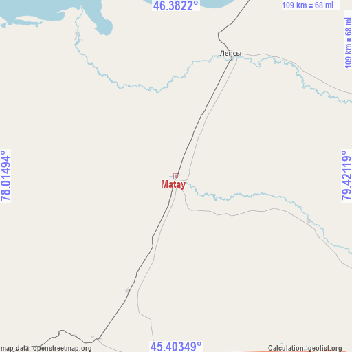
Matay GPS coordinates[2]
45° 53' 42" North, 78° 43' 5.016" East
| Map corner | latitude | longitude |
|---|---|---|
| Upper-left | 46.3822°, | 78.01494° |
| Center: | 45.895°, | 78.71806° |
| Lower-right: | 45.40349°, | 79.42119° |
| Map W x H: | 108.8×108.8 km | = 67.6×67.6mi |
| max Lat: | 54.90596° ⇑67.4% North |
| Matay: | 45.895° |
| min Lat: | ⇓32.6% South 40.66338° |
| min Long | Matay | max Long |
| 46.83361° | 78.71806° | 84.87144° |
| W 85.6%⇐ | ⇒14.4% E |
Elevation
Elevation of Matay is 412 m = 1352 ft, and this is 55.5 m = 182 ft above average elevation for this country.
| Max E: |
1847 m = 6060 ft | 37% |
| Matay | 412 m 1352 ft | |
| Avg. | 356.5 m = 1170 ft | |
Min E: |
-26 m = -85 ft | 63% |
See also: Kazakhstan elevation on elevation.city.
Geographical zone
Matay is located in North temperate zone (between Tropic of Cancer and the Arctic Circle). Distance of this North polar circle is 2298.1 km =1428 mi to North.| Distance of | km | miles | from Matay |
|---|---|---|---|
| North Pole | 4904 | 3047.2 | to North |
| Arctic Circle | 2298.1 | 1428 | to North |
| Tropic Cancer | 2497.1 | 1551.6 | to South |
| Equator | 5103 | 3170.9 | to South |


Nearby cities:
15 places around Matay: (largest is in red/bold)
• Aqtoghay
138 km =85.7 mi,  31°
31°
• Bakanas
226.1 km =140.5 mi,  237°
237°
• Balpyk Bī
116.7 km =72.5 mi,  198°
198°
• Karabas
206.3 km =128.2 mi,  290°
290°
• Lepsy
41.7 km =25.9 mi,  24°
24°
• Molaly
58.3 km =36.2 mi,  212°
212°
• Sarkand
107.5 km =66.8 mi,  120°
120°
• Sarykamys
210 km =130.5 mi,  359°
359°
• Saryozek
180.2 km =112 mi, 198°
• Sayaq
165.7 km =103 mi,  317°
317°
• Taldykorgan
101.4 km =63 mi, 195°
• Tekeli
118.4 km =73.6 mi,  175°
175°
• Urzhar
259.6 km =161.3 mi,  59°
59°
• Ush-Tyube
91.7 km =57 mi,  218°
218°
• Zharkent
217.2 km =135 mi,  152°
152°
Sources, notices
• [Note1] Compared only with cities in Kazakhstan existing in our database
• [Src1] Map data: © OpenStreetMap contributors (CC-BY-SA)
• [Src2] Other city data from geonames.org with taken over terms of usage.
• [Src3] Geographical zone / Annual Mean Temperature by Robert A. Rohde @ Wikipedia
