Sarkand geodata
Sarkand (Almaty Oblysy) is a populated place; located in Kazakhstan in Asia/Almaty (GMT+5) time zone. With population of 76,919 people, there are 24 cities with bigger population in this country. Compared to other cities in Kazakhstan, 70.4% of cities are located further ↑North; 87.8% of cities are located further ←West and 93.7% of cities have lower elevation than Sarkand. Note1


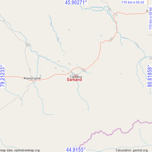
Sarkand GPS coordinates[2]
45° 24' 40.536" North, 79° 54' 55.62" East
| Map corner | latitude | longitude |
|---|---|---|
| Upper-left | 45.90271°, | 79.21233° |
| Center: | 45.41126°, | 79.91545° |
| Lower-right: | 44.9155°, | 80.61858° |
| Map W x H: | 109.8×109.8 km | = 68.2×68.2mi |
| max Lat: | 54.90596° ⇑70.4% North |
| Sarkand: | 45.41126° |
| min Lat: | ⇓29.6% South 40.66338° |
| min Long | Sarkand | max Long |
| 46.83361° | 79.91545° | 84.87144° |
| W 87.8%⇐ | ⇒12.2% E |
Elevation
Elevation of Sarkand is 772 m = 2533 ft, and this is 415.5 m = 1363 ft above average elevation for this country.
| Max E: |
1847 m = 6060 ft | 6.3% |
| Sarkand | 772 m 2533 ft | |
| Avg. | 356.5 m = 1170 ft | |
Min E: |
-26 m = -85 ft | 93.7% |
See also: Sarkand elevation on elevation.city.
Geographical zone
Sarkand is located in North temperate zone (between Tropic of Cancer and the Arctic Circle). Distance of this North polar circle is 2351.9 km =1461.4 mi to North.| Distance of | km | miles | from Sarkand |
|---|---|---|---|
| North Pole | 4957.8 | 3080.6 | to North |
| Arctic Circle | 2351.9 | 1461.4 | to North |
| Tropic Cancer | 2443.3 | 1518.2 | to South |
| Equator | 5049.3 | 3137.5 | to South |


Nearby cities:
15 places around Sarkand: (largest is in red/bold)
• Aqtoghay
172.2 km =107 mi,  353°
353°
• Balpyk Bī
143.6 km =89.2 mi,  246°
246°
• Druzhba
201.3 km =125.1 mi,  95°
95°
• Kegen
271.4 km =168.6 mi,  191°
191°
• Lepsy
118.5 km =73.6 mi,  320°
320°
• Matay
107.5 km =66.8 mi,  300°
300°
• Molaly
125 km =77.7 mi,  272°
272°
• Sarykamys
279.2 km =173.5 mi,  340°
340°
• Saryozek
192.4 km =119.6 mi,  232°
232°
• Sayaq
269.7 km =167.6 mi,  310°
310°
• Taldykorgan
128.5 km =79.8 mi, 249°
• Tekeli
106.6 km =66.2 mi, 232°
• Urzhar
228.7 km =142.1 mi,  35°
35°
• Ush-Tyube
152.3 km =94.6 mi,  263°
263°
• Zharkent
138.6 km =86.1 mi,  177°
177°
Sources, notices
• [Note1] Compared only with cities in Kazakhstan existing in our database
• [Src1] Map data: © OpenStreetMap contributors (CC-BY-SA)
• [Src2] Other city data from geonames.org with taken over terms of usage.
• [Src3] Geographical zone / Annual Mean Temperature by Robert A. Rohde @ Wikipedia
