Lepsy geodata
Lepsy (Almaty Oblysy) is a populated place; located in Kazakhstan in Asia/Almaty (GMT+5) time zone. With population of 5,350 people, there are 184 cities with bigger population in this country. Compared to other cities in Kazakhstan, 66.3% of cities are located further ↑North; 86.3% of cities are located further ←West and 61.5% of cities have lower elevation than Lepsy. Note1


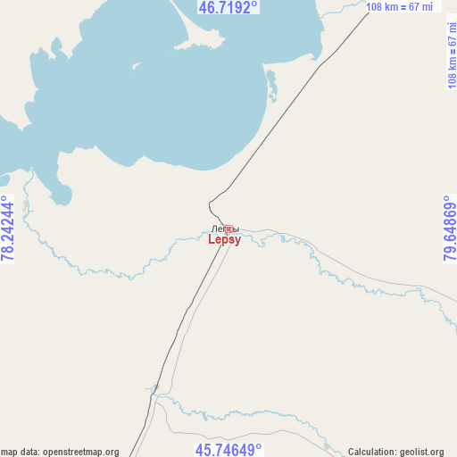
Lepsy GPS coordinates[2]
46° 14' 6" North, 78° 56' 44.016" East
| Map corner | latitude | longitude |
|---|---|---|
| Upper-left | 46.7192°, | 78.24244° |
| Center: | 46.235°, | 78.94556° |
| Lower-right: | 45.74649°, | 79.64869° |
| Map W x H: | 108.2×108.2 km | = 67.2×67.2mi |
| max Lat: | 54.90596° ⇑66.3% North |
| Lepsy: | 46.235° |
| min Lat: | ⇓33.7% South 40.66338° |
| min Long | Lepsy | max Long |
| 46.83361° | 78.94556° | 84.87144° |
| W 86.3%⇐ | ⇒13.7% E |
Elevation
Elevation of Lepsy is 401 m = 1316 ft, and this is 44.5 m = 146 ft above average elevation for this country.
| Max E: |
1847 m = 6060 ft | 38.5% |
| Lepsy | 401 m 1316 ft | |
| Avg. | 356.5 m = 1170 ft | |
Min E: |
-26 m = -85 ft | 61.5% |
See also: Kazakhstan elevation on elevation.city.
Geographical zone
Lepsy is located in North temperate zone (between Tropic of Cancer and the Arctic Circle). Distance of this North polar circle is 2260.3 km =1404.5 mi to North.| Distance of | km | miles | from Lepsy |
|---|---|---|---|
| North Pole | 4866.2 | 3023.7 | to North |
| Arctic Circle | 2260.3 | 1404.5 | to North |
| Tropic Cancer | 2534.9 | 1575.1 | to South |
| Equator | 5140.9 | 3194.4 | to South |


Nearby cities:
15 places around Lepsy: (largest is in red/bold)
• Aqtoghay
96.7 km =60.1 mi,  34°
34°
• Ayagoz
222.9 km =138.5 mi, 30°
• Balpyk Bī
158.3 km =98.4 mi,  200°
200°
• Karabas
213.2 km =132.5 mi,  278°
278°
• Matay
41.7 km =25.9 mi, 204°
• Molaly
99.8 km =62 mi,  209°
209°
• Sarkand
118.5 km =73.6 mi,  140°
140°
• Sarykamys
173 km =107.5 mi,  354°
354°
• Saryozek
221.7 km =137.8 mi, 200°
• Sayaq
153.9 km =95.6 mi,  303°
303°
• Taldykorgan
142.7 km =88.7 mi, 198°
• Tekeli
156.1 km =97 mi,  183°
183°
• Urzhar
225.9 km =140.4 mi,  65°
65°
• Ush-Tyube
132.5 km =82.3 mi, 214°
• Zharkent
244.5 km =151.9 mi,  160°
160°
Sources, notices
• [Note1] Compared only with cities in Kazakhstan existing in our database
• [Src1] Map data: © OpenStreetMap contributors (CC-BY-SA)
• [Src2] Other city data from geonames.org with taken over terms of usage.
• [Src3] Geographical zone / Annual Mean Temperature by Robert A. Rohde @ Wikipedia
