Druzhba geodata
Druzhba (Almaty Oblysy) is a populated place; located in Kazakhstan in Asia/Almaty (GMT+5) time zone. With population of 2,930 people, there are 231 cities with bigger population in this country. Compared to other cities in Kazakhstan, 71.1% of cities are located further ↑North; 94.8% of cities are located further ←West and 64.1% of cities have lower elevation than Druzhba. Note1


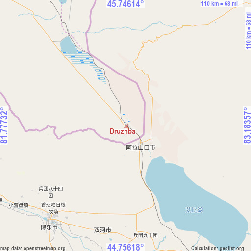
Druzhba GPS coordinates[2]
45° 15' 11.952" North, 82° 28' 49.584" East
| Map corner | latitude | longitude |
|---|---|---|
| Upper-left | 45.74614°, | 81.77732° |
| Center: | 45.25332°, | 82.48044° |
| Lower-right: | 44.75618°, | 83.18357° |
| Map W x H: | 110.1×110.1 km | = 68.4×68.4mi |
| max Lat: | 54.90596° ⇑71.1% North |
| Druzhba: | 45.25332° |
| min Lat: | ⇓28.9% South 40.66338° |
| min Long | Druzhba | max Long |
| 46.83361° | 82.48044° | 84.87144° |
| W 94.8%⇐ | ⇒5.2% E |
Elevation
Elevation of Druzhba is 424 m = 1391 ft, and this is 67.5 m = 221 ft above average elevation for this country.
| Max E: |
1847 m = 6060 ft | 35.9% |
| Druzhba | 424 m 1391 ft | |
| Avg. | 356.5 m = 1170 ft | |
Min E: |
-26 m = -85 ft | 64.1% |
See also: Kazakhstan elevation on elevation.city.
Geographical zone
Druzhba is located in North temperate zone (between Tropic of Cancer and the Arctic Circle). Distance of this North polar circle is 2369.5 km =1472.3 mi to North.| Distance of | km | miles | from Druzhba |
|---|---|---|---|
| North Pole | 4975.4 | 3091.6 | to North |
| Arctic Circle | 2369.5 | 1472.3 | to North |
| Tropic Cancer | 2425.8 | 1507.3 | to South |
| Equator | 5031.7 | 3126.6 | to South |


Nearby cities:
15 places around Druzhba: (largest is in red/bold)
• Aksuat
396 km =246.1 mi,  13°
13°
• Aqtoghay
287.5 km =178.6 mi,  311°
311°
• Ayagoz
339.5 km =211 mi,  332°
332°
• Kegen
359.5 km =223.4 mi,  226°
226°
• Kokpekty
388.8 km =241.6 mi,  359°
359°
• Kurchum
379.1 km =235.6 mi, 13°
• Lepsy
295.2 km =183.4 mi,  291°
291°
• Matay
301.4 km =187.3 mi,  283°
283°
• Narynkol
336.1 km =208.8 mi,  213°
213°
• Sarkand
201.3 km =125.1 mi, 275°
• Tekeli
290.5 km =180.5 mi,  260°
260°
• Tūghyl
304.9 km =189.5 mi,  25°
25°
• Urzhar
214.8 km =133.5 mi,  342°
342°
• Zaysan
306.9 km =190.7 mi,  36°
36°
• Zharkent
229.8 km =142.8 mi,  238°
238°
Sources, notices
• [Note1] Compared only with cities in Kazakhstan existing in our database
• [Src1] Map data: © OpenStreetMap contributors (CC-BY-SA)
• [Src2] Other city data from geonames.org with taken over terms of usage.
• [Src3] Geographical zone / Annual Mean Temperature by Robert A. Rohde @ Wikipedia
