Smirnovo geodata
Smirnovo (Soltüstik Qazaqstan) is a populated place; located in Kazakhstan in Asia/Almaty (GMT+5) time zone. With population of 5,742 people, there are 176 cities with bigger population in this country. Compared to other cities in Kazakhstan, 98.9% of cities are located further ↓South; 55.9% of cities are located further →East and 76.3% of cities have higher elevation than Smirnovo. Note1


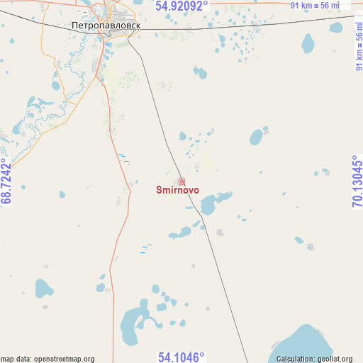
Smirnovo GPS coordinates[2]
54° 30' 53.28" North, 69° 25' 38.352" East
| Map corner | latitude | longitude |
|---|---|---|
| Upper-left | 54.92092°, | 68.7242° |
| Center: | 54.5148°, | 69.42732° |
| Lower-right: | 54.1046°, | 70.13045° |
| Map W x H: | 90.8×90.8 km | = 56.4×56.4mi |
| max Lat: | 54.90596° ⇑1.1% North |
| Smirnovo: | 54.5148° |
| min Lat: | ⇓98.9% South 40.66338° |
| min Long | Smirnovo | max Long |
| 46.83361° | 69.42732° | 84.87144° |
| W 44.1%⇐ | ⇒55.9% E |
Elevation
Elevation of Smirnovo is 135 m = 443 ft, and this is 221.5 m = 727 ft below average elevation for this country.
| Max E: |
1847 m = 6060 ft | 76.3% |
| Avg. | 356.5 m = 1170 ft | |
| Smirnovo | 135 m = 443 ft | |
Min E: |
-26 m = -85 ft | 23.7% |
See also: Kazakhstan elevation on elevation.city.
Geographical zone
Smirnovo is located in North temperate zone (between Tropic of Cancer and the Arctic Circle). Distance of this North polar circle is 1339.7 km =832.5 mi to North.| Distance of | km | miles | from Smirnovo |
|---|---|---|---|
| North Pole | 3945.6 | 2451.7 | to North |
| Arctic Circle | 1339.7 | 832.5 | to North |
| Tropic Cancer | 3455.6 | 2147.2 | to South |
| Equator | 6061.5 | 3766.4 | to South |


Nearby cities:
15 places around Smirnovo: (largest is in red/bold)
• Akkol’
136 km =84.5 mi,  175°
175°
• Birlestik
125 km =77.7 mi,  214°
214°
• Bishkul
36 km =22.4 mi,  324°
324°
• Bulayevo
78.3 km =48.7 mi,  56°
56°
• Būrabay
169.4 km =105.3 mi,  159°
159°
• Kokshetau
136.9 km =85.1 mi, 180°
• Petropavl
43 km =26.7 mi,  335°
335°
• Sergeyevka
149 km =92.6 mi,  241°
241°
• Shchuchinsk
182.6 km =113.5 mi, 164°
• Stepnyak
207.2 km =128.7 mi,  154°
154°
• Taiynsha
77.4 km =48.1 mi, 163°
• Talshik
187.1 km =116.3 mi,  121°
121°
• Timiryazevo
209.5 km =130.2 mi,  246°
246°
• Volodarskoye
161.1 km =100.1 mi, 212°
• Yavlenka
65.5 km =40.7 mi, 253°
Sources, notices
• [Note1] Compared only with cities in Kazakhstan existing in our database
• [Src1] Map data: © OpenStreetMap contributors (CC-BY-SA)
• [Src2] Other city data from geonames.org with taken over terms of usage.
• [Src3] Geographical zone / Annual Mean Temperature by Robert A. Rohde @ Wikipedia
