Bishkul geodata
Bishkul (Soltüstik Qazaqstan) is a populated place; located in Kazakhstan in Asia/Almaty (GMT+5) time zone. With population of 5,423 people, there are 182 cities with bigger population in this country. Compared to other cities in Kazakhstan, 99.3% of cities are located further ↓South; 58.9% of cities are located further →East and 83% of cities have higher elevation than Bishkul. Note1


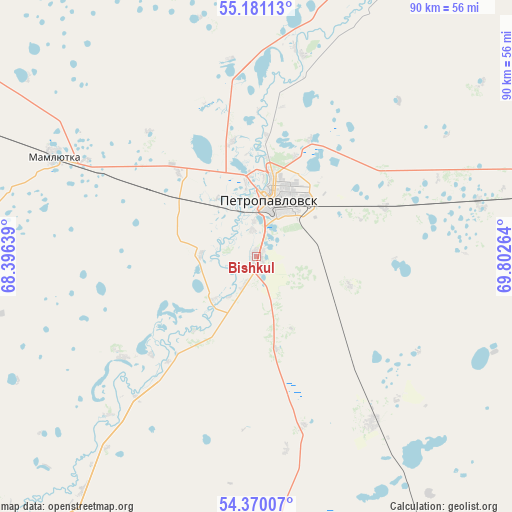
Bishkul GPS coordinates[2]
54° 46' 39.468" North, 69° 5' 58.236" East
| Map corner | latitude | longitude |
|---|---|---|
| Upper-left | 55.18113°, | 68.39639° |
| Center: | 54.77763°, | 69.09951° |
| Lower-right: | 54.37007°, | 69.80264° |
| Map W x H: | 90.2×90.2 km | = 56×56mi |
| max Lat: | 54.90596° ⇑0.7% North |
| Bishkul: | 54.77763° |
| min Lat: | ⇓99.3% South 40.66338° |
| min Long | Bishkul | max Long |
| 46.83361° | 69.09951° | 84.87144° |
| W 41.1%⇐ | ⇒58.9% E |
Elevation
Elevation of Bishkul is 103 m = 338 ft, and this is 253.5 m = 832 ft below average elevation for this country.
| Max E: |
1847 m = 6060 ft | 83% |
| Avg. | 356.5 m = 1170 ft | |
| Bishkul | 103 m = 338 ft | |
Min E: |
-26 m = -85 ft | 17% |
See also: Kazakhstan elevation on elevation.city.
Geographical zone
Bishkul is located in North temperate zone (between Tropic of Cancer and the Arctic Circle). Distance of this North polar circle is 1310.5 km =814.3 mi to North.| Distance of | km | miles | from Bishkul |
|---|---|---|---|
| North Pole | 3916.4 | 2433.5 | to North |
| Arctic Circle | 1310.5 | 814.3 | to North |
| Tropic Cancer | 3484.8 | 2165.4 | to South |
| Equator | 6090.7 | 3784.6 | to South |


Nearby cities:
15 places around Bishkul: (largest is in red/bold)
• Akkol’
167.9 km =104.3 mi,  168°
168°
• Birlestik
141.3 km =87.8 mi,  200°
200°
• Bulayevo
87.1 km =54.1 mi,  80°
80°
• Būrabay
204.4 km =127 mi,  157°
157°
• Kokshetau
167.3 km =104 mi, 173°
• Petropavl
10.4 km =6.5 mi,  18°
18°
• Sergeyevka
148.1 km =92 mi,  227°
227°
• Shchuchinsk
216.9 km =134.8 mi, 160°
• Smirnovo
36 km =22.4 mi,  144°
144°
• Taiynsha
112.1 km =69.7 mi, 157°
• Talshik
220.5 km =137 mi,  125°
125°
• Timiryazevo
204.5 km =127.1 mi,  236°
236°
• Troyebratskiy
198 km =123 mi,  259°
259°
• Volodarskoye
177.4 km =110.2 mi, 201°
• Yavlenka
63.4 km =39.4 mi,  220°
220°
Sources, notices
• [Note1] Compared only with cities in Kazakhstan existing in our database
• [Src1] Map data: © OpenStreetMap contributors (CC-BY-SA)
• [Src2] Other city data from geonames.org with taken over terms of usage.
• [Src3] Geographical zone / Annual Mean Temperature by Robert A. Rohde @ Wikipedia
