Merke geodata
Merke (Zhambyl) is a populated place; located in Kazakhstan in Asia/Almaty (GMT+5) time zone. With population of 15,934 people, there are 76 cities with bigger population in this country. Compared to other cities in Kazakhstan, 92.6% of cities are located further ↑North; 66.3% of cities are located further ←West and 90.4% of cities have lower elevation than Merke. Note1


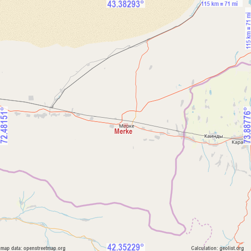
Merke GPS coordinates[2]
42° 52' 11.136" North, 73° 11' 4.668" East
| Map corner | latitude | longitude |
|---|---|---|
| Upper-left | 43.38293°, | 72.48151° |
| Center: | 42.86976°, | 73.18463° |
| Lower-right: | 42.35229°, | 73.88776° |
| Map W x H: | 114.6×114.6 km | = 71.2×71.2mi |
| max Lat: | 54.90596° ⇑92.6% North |
| Merke: | 42.86976° |
| min Lat: | ⇓7.4% South 40.66338° |
| min Long | Merke | max Long |
| 46.83361° | 73.18463° | 84.87144° |
| W 66.3%⇐ | ⇒33.7% E |
Elevation
Elevation of Merke is 700 m = 2297 ft, and this is 343.5 m = 1127 ft above average elevation for this country.
| Max E: |
1847 m = 6060 ft | 9.6% |
| Merke | 700 m 2297 ft | |
| Avg. | 356.5 m = 1170 ft | |
Min E: |
-26 m = -85 ft | 90.4% |
See also: Kazakhstan elevation on elevation.city.
Geographical zone
Merke is located in North temperate zone (between Tropic of Cancer and the Arctic Circle). Distance of this Northern Tropic circle is 2160.8 km =1342.7 mi to South.| Distance of | km | miles | from Merke |
|---|---|---|---|
| North Pole | 5240.4 | 3256.2 | to North |
| Arctic Circle | 2634.5 | 1637 | to North |
| Tropic Cancer | 2160.8 | 1342.7 | to South |
| Equator | 4766.7 | 2961.9 | to South |


Nearby cities:
15 places around Merke: (largest is in red/bold)
• Aqbaqay
239 km =148.5 mi,  352°
352°
• Chu
93.9 km =58.3 mi,  29°
29°
• Georgiyevka
125.8 km =78.2 mi,  81°
81°
• Granitogorsk
27 km =16.8 mi,  121°
121°
• Karatau
223.5 km =138.9 mi,  278°
278°
• Khantaū
158.8 km =98.7 mi,  18°
18°
• Lugovoy
35.4 km =22 mi, 283°
• Lugovoye
38.1 km =23.7 mi, 276°
• Moyynkum
158.6 km =98.5 mi, 352°
• Oytal
8 km =5 mi,  60°
60°
• Sarykemer
137.9 km =85.7 mi, 276°
• Taraz
148.1 km =92 mi,  271°
271°
• Turar Ryskulov
234.6 km =145.8 mi,  260°
260°
• Tyul’kubas
239.9 km =149.1 mi, 259°
• Zhabagly
226.4 km =140.7 mi, 257°
Sources, notices
• [Note1] Compared only with cities in Kazakhstan existing in our database
• [Src1] Map data: © OpenStreetMap contributors (CC-BY-SA)
• [Src2] Other city data from geonames.org with taken over terms of usage.
• [Src3] Geographical zone / Annual Mean Temperature by Robert A. Rohde @ Wikipedia
