Granitogorsk geodata
Granitogorsk (Zhambyl) is a populated place; located in Kazakhstan in Asia/Almaty (GMT+5) time zone. With population of 2,004 people, there are 245 cities with bigger population in this country. Compared to other cities in Kazakhstan, 93.3% of cities are located further ↑North; 68.1% of cities are located further ←West and 98.5% of cities have lower elevation than Granitogorsk. Note1


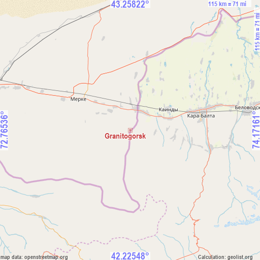
Granitogorsk GPS coordinates[2]
42° 44' 38.4" North, 73° 28' 6.528" East
| Map corner | latitude | longitude |
|---|---|---|
| Upper-left | 43.25822°, | 72.76536° |
| Center: | 42.744°, | 73.46848° |
| Lower-right: | 42.22548°, | 74.17161° |
| Map W x H: | 114.8×114.8 km | = 71.3×71.3mi |
| max Lat: | 54.90596° ⇑93.3% North |
| Granitogorsk: | 42.744° |
| min Lat: | ⇓6.7% South 40.66338° |
| min Long | Granitogorsk | max Long |
| 46.83361° | 73.46848° | 84.87144° |
| W 68.1%⇐ | ⇒31.9% E |
Elevation
Elevation of Granitogorsk is 1059 m = 3474 ft, and this is 702.5 m = 2305 ft above average elevation for this country.
| Max E: |
1847 m = 6060 ft | 1.5% |
| Granitogorsk | 1059 m 3474 ft | |
| Avg. | 356.5 m = 1170 ft | |
Min E: |
-26 m = -85 ft | 98.5% |
See also: Kazakhstan elevation on elevation.city.
Geographical zone
Granitogorsk is located in North temperate zone (between Tropic of Cancer and the Arctic Circle). Distance of this Northern Tropic circle is 2146.8 km =1334 mi to South.| Distance of | km | miles | from Granitogorsk |
|---|---|---|---|
| North Pole | 5254.4 | 3264.9 | to North |
| Arctic Circle | 2648.5 | 1645.7 | to North |
| Tropic Cancer | 2146.8 | 1334 | to South |
| Equator | 4752.7 | 2953.2 | to South |


Nearby cities:
15 places around Granitogorsk: (largest is in red/bold)
• Aqbaqay
256.8 km =159.6 mi,  347°
347°
• Chu
98.4 km =61.1 mi,  13°
13°
• Georgiyevka
106.5 km =66.2 mi,  72°
72°
• Karatau
248.9 km =154.7 mi,  281°
281°
• Khantaū
167 km =103.8 mi, 9°
• Lugovoy
61.7 km =38.3 mi,  290°
290°
• Lugovoye
63.7 km =39.6 mi, 286°
• Merke
27 km =16.8 mi,  301°
301°
• Moyynkum
176.5 km =109.7 mi, 346°
• Oytal
24.2 km =15 mi,  317°
317°
• Sarykemer
162.9 km =101.2 mi, 280°
• Taraz
172.3 km =107.1 mi, 275°
• Turar Ryskulov
256.2 km =159.2 mi,  264°
264°
• Tyul’kubas
261.2 km =162.3 mi, 263°
• Zhabagly
247.1 km =153.5 mi, 262°
Sources, notices
• [Note1] Compared only with cities in Kazakhstan existing in our database
• [Src1] Map data: © OpenStreetMap contributors (CC-BY-SA)
• [Src2] Other city data from geonames.org with taken over terms of usage.
• [Src3] Geographical zone / Annual Mean Temperature by Robert A. Rohde @ Wikipedia
