Arkalyk geodata
Arkalyk (Qostanay) is a populated place; located in Kazakhstan in Asia/Qostanay (GMT+5) time zone. With population of 42,000 people, there are 37 cities with bigger population in this country. Compared to other cities in Kazakhstan, 68.1% of cities are located further ↓South; 67.8% of cities are located further →East and 53% of cities have lower elevation than Arkalyk. Note1


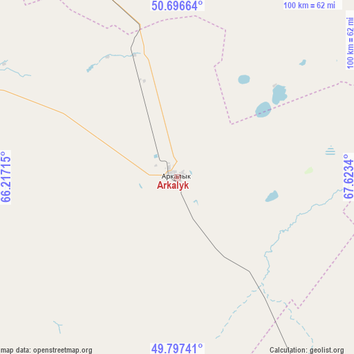
Arkalyk GPS coordinates[2]
50° 14' 56.94" North, 66° 55' 12.972" East
| Map corner | latitude | longitude |
|---|---|---|
| Upper-left | 50.69664°, | 66.21715° |
| Center: | 50.24915°, | 66.92027° |
| Lower-right: | 49.79741°, | 67.6234° |
| Map W x H: | 100×100 km | = 62.1×62.1mi |
| max Lat: | 54.90596° ⇑31.9% North |
| Arkalyk: | 50.24915° |
| min Lat: | ⇓68.1% South 40.66338° |
| min Long | Arkalyk | max Long |
| 46.83361° | 66.92027° | 84.87144° |
| W 32.2%⇐ | ⇒67.8% E |
Elevation
Elevation of Arkalyk is 349 m = 1145 ft, and this is 7.5 m = 25 ft below average elevation for this country.
| Max E: |
1847 m = 6060 ft | 47% |
| Avg. | 356.5 m = 1170 ft | |
| Arkalyk | 349 m = 1145 ft | |
Min E: |
-26 m = -85 ft | 53% |
See also: Arkalyk elevation on elevation.city.
Geographical zone
Arkalyk is located in North temperate zone (between Tropic of Cancer and the Arctic Circle). Distance of this North polar circle is 1814 km =1127.2 mi to North.| Distance of | km | miles | from Arkalyk |
|---|---|---|---|
| North Pole | 4419.9 | 2746.4 | to North |
| Arctic Circle | 1814 | 1127.2 | to North |
| Tropic Cancer | 2981.3 | 1852.5 | to South |
| Equator | 5587.2 | 3471.7 | to South |


Nearby cities:
15 places around Arkalyk: (largest is in red/bold)
• Astrakhan
247 km =153.5 mi,  54°
54°
• Atbasar
198.7 km =123.5 mi,  29°
29°
• Atbasar
200.3 km =124.5 mi, 30°
• Balkashino
282.4 km =175.5 mi, 26°
• Derzhavīnsk
103.7 km =64.4 mi,  335°
335°
• Egindiköl
201.4 km =125.1 mi,  63°
63°
• Esil
193 km =119.9 mi,  349°
349°
• Karasu
285.9 km =177.7 mi, 339°
• Krasnogorskiy
223.7 km =139 mi, 352°
• Shantobe
260.1 km =161.6 mi,  19°
19°
• Shubarköl
204 km =126.8 mi,  138°
138°
• Torghay
254.2 km =158 mi,  254°
254°
• Volodarskoye
269.1 km =167.2 mi,  355°
355°
• Zhaqsy
186.8 km =116.1 mi,  8°
8°
• Zhezqazghan
281 km =174.6 mi,  167°
167°
Sources, notices
• [Note1] Compared only with cities in Kazakhstan existing in our database
• [Src1] Map data: © OpenStreetMap contributors (CC-BY-SA)
• [Src2] Other city data from geonames.org with taken over terms of usage.
• [Src3] Geographical zone / Annual Mean Temperature by Robert A. Rohde @ Wikipedia
