Asyqata geodata
Asyqata (South Kazakhstan) is a populated place; located in Kazakhstan in Asia/Almaty (GMT+5) time zone. With population of 11,378 people, there are 103 cities with bigger population in this country. Compared to other cities in Kazakhstan, 99.3% of cities are located further ↑North; 62.6% of cities are located further →East and 56.7% of cities have higher elevation than Asyqata. Note1


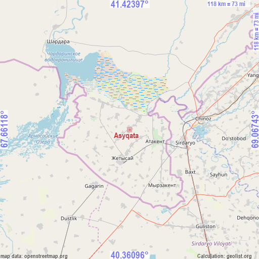
Asyqata GPS coordinates[2]
40° 53' 40.56" North, 68° 21' 51.48" East
| Map corner | latitude | longitude |
|---|---|---|
| Upper-left | 41.42397°, | 67.66118° |
| Center: | 40.8946°, | 68.3643° |
| Lower-right: | 40.36096°, | 69.06743° |
| Map W x H: | 118.2×118.2 km | = 73.4×73.4mi |
| max Lat: | 54.90596° ⇑99.3% North |
| Asyqata: | 40.8946° |
| min Lat: | ⇓0.7% South 40.66338° |
| min Long | Asyqata | max Long |
| 46.83361° | 68.3643° | 84.87144° |
| W 37.4%⇐ | ⇒62.6% E |
Elevation
Elevation of Asyqata is 265 m = 869 ft, and this is 91.5 m = 300 ft below average elevation for this country.
| Max E: |
1847 m = 6060 ft | 56.7% |
| Avg. | 356.5 m = 1170 ft | |
| Asyqata | 265 m = 869 ft | |
Min E: |
-26 m = -85 ft | 43.3% |
See also: Kazakhstan elevation on elevation.city.
Geographical zone
Asyqata is located in North temperate zone (between Tropic of Cancer and the Arctic Circle). Distance of this Northern Tropic circle is 1941.1 km =1206.1 mi to South.| Distance of | km | miles | from Asyqata |
|---|---|---|---|
| North Pole | 5460 | 3392.7 | to North |
| Arctic Circle | 2854.1 | 1773.5 | to North |
| Tropic Cancer | 1941.1 | 1206.1 | to South |
| Equator | 4547.1 | 2825.4 | to South |


Nearby cities:
15 places around Asyqata: (largest is in red/bold)
• Arys
174.7 km =108.6 mi,  12°
12°
• Atakent
13 km =8.1 mi,  113°
113°
• Belyye Vody
208.8 km =129.7 mi,  35°
35°
• Chardara
52.2 km =32.4 mi,  320°
320°
• Kokterek
237.2 km =147.4 mi, 41°
• Lenger
191.1 km =118.7 mi, 41°
• Leninskoye
128.2 km =79.7 mi, 41°
• Myrzakent
29.9 km =18.6 mi,  149°
149°
• Qogham
215.1 km =133.7 mi,  358°
358°
• Saryaghash
92.1 km =57.2 mi,  46°
46°
• Sastobe
228.9 km =142.2 mi, 36°
• Sayram
194.7 km =121 mi, 36°
• Shymkent
187 km =116.2 mi,  33°
33°
• Temirlanovka
203.6 km =126.5 mi,  21°
21°
• Tyul’kubas
238.8 km =148.4 mi, 42°
Sources, notices
• [Note1] Compared only with cities in Kazakhstan existing in our database
• [Src1] Map data: © OpenStreetMap contributors (CC-BY-SA)
• [Src2] Other city data from geonames.org with taken over terms of usage.
• [Src3] Geographical zone / Annual Mean Temperature by Robert A. Rohde @ Wikipedia
