Qogham geodata
Qogham (South Kazakhstan) is a populated place; located in Kazakhstan in Asia/Almaty (GMT+5) time zone. With population of 2,276 people, there are 242 cities with bigger population in this country. Compared to other cities in Kazakhstan, 93% of cities are located further ↑North; 64.1% of cities are located further →East and 67.4% of cities have higher elevation than Qogham. Note1


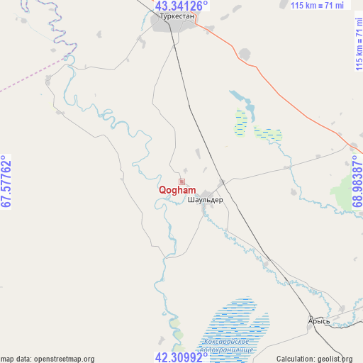
Qogham GPS coordinates[2]
42° 49' 39.864" North, 68° 16' 50.664" East
| Map corner | latitude | longitude |
|---|---|---|
| Upper-left | 43.34126°, | 67.57762° |
| Center: | 42.82774°, | 68.28074° |
| Lower-right: | 42.30992°, | 68.98387° |
| Map W x H: | 114.7×114.7 km | = 71.3×71.3mi |
| max Lat: | 54.90596° ⇑93% North |
| Qogham: | 42.82774° |
| min Lat: | ⇓7% South 40.66338° |
| min Long | Qogham | max Long |
| 46.83361° | 68.28074° | 84.87144° |
| W 35.9%⇐ | ⇒64.1% E |
Elevation
Elevation of Qogham is 195 m = 640 ft, and this is 161.5 m = 530 ft below average elevation for this country.
| Max E: |
1847 m = 6060 ft | 67.4% |
| Avg. | 356.5 m = 1170 ft | |
| Qogham | 195 m = 640 ft | |
Min E: |
-26 m = -85 ft | 32.6% |
See also: Kazakhstan elevation on elevation.city.
Geographical zone
Qogham is located in North temperate zone (between Tropic of Cancer and the Arctic Circle). Distance of this Northern Tropic circle is 2156.1 km =1339.7 mi to South.| Distance of | km | miles | from Qogham |
|---|---|---|---|
| North Pole | 5245.1 | 3259.2 | to North |
| Arctic Circle | 2639.2 | 1639.9 | to North |
| Tropic Cancer | 2156.1 | 1339.7 | to South |
| Equator | 4762 | 2959 | to South |


Nearby cities:
15 places around Qogham: (largest is in red/bold)
• Arys
61.8 km =38.4 mi,  135°
135°
• Ashchysay
95 km =59 mi,  31°
31°
• Bayzhansay
138.1 km =85.8 mi,  74°
74°
• Belyye Vody
134.3 km =83.5 mi,  109°
109°
• Chayan
92.4 km =57.4 mi,  75°
75°
• Chulakkurgan
127 km =78.9 mi, 34°
• Kantagi
81.6 km =50.7 mi,  17°
17°
• Kentau
78.7 km =48.9 mi,  13°
13°
• Sastobe
143.7 km =89.3 mi,  102°
102°
• Sayram
134.3 km =83.5 mi,  115°
115°
• Shymkent
122.9 km =76.4 mi, 118°
• Temirlanovka
83.8 km =52.1 mi, 107°
• Turkestan
52.3 km =32.5 mi,  357°
357°
• Yanykurgan
146.2 km =90.8 mi,  325°
325°
• Zhangatas
143.4 km =89.1 mi,  55°
55°
Sources, notices
• [Note1] Compared only with cities in Kazakhstan existing in our database
• [Src1] Map data: © OpenStreetMap contributors (CC-BY-SA)
• [Src2] Other city data from geonames.org with taken over terms of usage.
• [Src3] Geographical zone / Annual Mean Temperature by Robert A. Rohde @ Wikipedia
