Atakent geodata
Atakent (South Kazakhstan) is a populated place; located in Kazakhstan in Asia/Almaty (GMT+5) time zone. With population of 12,895 people, there are 96 cities with bigger population in this country. Compared to other cities in Kazakhstan, 99.6% of cities are located further ↑North; 61.5% of cities are located further →East and 57.4% of cities have higher elevation than Atakent. Note1


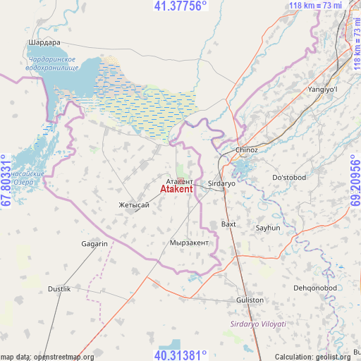
Atakent GPS coordinates[2]
40° 50' 52.152" North, 68° 30' 23.148" East
| Map corner | latitude | longitude |
|---|---|---|
| Upper-left | 41.37756°, | 67.80331° |
| Center: | 40.84782°, | 68.50643° |
| Lower-right: | 40.31381°, | 69.20956° |
| Map W x H: | 118.3×118.3 km | = 73.5×73.5mi |
| max Lat: | 54.90596° ⇑99.6% North |
| Atakent: | 40.84782° |
| min Lat: | ⇓0.4% South 40.66338° |
| min Long | Atakent | max Long |
| 46.83361° | 68.50643° | 84.87144° |
| W 38.5%⇐ | ⇒61.5% E |
Elevation
Elevation of Atakent is 263 m = 863 ft, and this is 93.5 m = 307 ft below average elevation for this country.
| Max E: |
1847 m = 6060 ft | 57.4% |
| Avg. | 356.5 m = 1170 ft | |
| Atakent | 263 m = 863 ft | |
Min E: |
-26 m = -85 ft | 42.6% |
See also: Kazakhstan elevation on elevation.city.
Geographical zone
Atakent is located in North temperate zone (between Tropic of Cancer and the Arctic Circle). Distance of this Northern Tropic circle is 1935.9 km =1202.9 mi to South.| Distance of | km | miles | from Atakent |
|---|---|---|---|
| North Pole | 5465.2 | 3395.9 | to North |
| Arctic Circle | 2859.3 | 1776.7 | to North |
| Tropic Cancer | 1935.9 | 1202.9 | to South |
| Equator | 4541.9 | 2822.2 | to South |


Nearby cities:
15 places around Atakent: (largest is in red/bold)
• Arys
177.7 km =110.4 mi,  8°
8°
• Asyqata
13 km =8.1 mi,  293°
293°
• Belyye Vody
206.6 km =128.4 mi,  32°
32°
• Chardara
64.1 km =39.8 mi,  315°
315°
• Kokterek
233.7 km =145.2 mi,  38°
38°
• Lenger
187.6 km =116.6 mi, 37°
• Leninskoye
124.8 km =77.5 mi, 35°
• Myrzakent
20.8 km =12.9 mi,  170°
170°
• Qogham
220.9 km =137.3 mi,  355°
355°
• Saryaghash
87.8 km =54.6 mi, 39°
• Sastobe
226.5 km =140.7 mi, 33°
• Sayram
192.3 km =119.5 mi, 32°
• Shymkent
185.3 km =115.1 mi, 29°
• Temirlanovka
204.6 km =127.1 mi,  17°
17°
• Tyul’kubas
235.1 km =146.1 mi, 39°
Sources, notices
• [Note1] Compared only with cities in Kazakhstan existing in our database
• [Src1] Map data: © OpenStreetMap contributors (CC-BY-SA)
• [Src2] Other city data from geonames.org with taken over terms of usage.
• [Src3] Geographical zone / Annual Mean Temperature by Robert A. Rohde @ Wikipedia
