Mişrātah geodata
Mişrātah is a seat of a first-order administrative division; located in Libya in Africa/Tripoli (GMT+2) time zone. With population of 386,120 people, there are 2 cities with bigger population in this country. Compared to other cities in Libya, 64.2% of cities are located further ↓South; 56.6% of cities are located further ←West and 79.2% of cities have higher elevation than Mişrātah. Note1


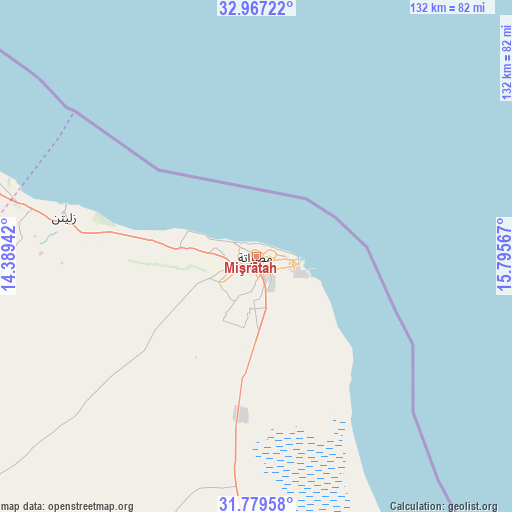
Mişrātah GPS coordinates[2]
32° 22' 31.26" North, 15° 5' 33.144" East
| Map corner | latitude | longitude |
|---|---|---|
| Upper-left | 32.96722°, | 14.38942° |
| Center: | 32.37535°, | 15.09254° |
| Lower-right: | 31.77958°, | 15.79567° |
| Map W x H: | 132.1×132.1 km | = 82.1×82.1mi |
| max Lat: | 32.94699° ⇑35.8% North |
| Mişrātah: | 32.37535° |
| min Lat: | ⇓64.2% South 24.1989° |
| min Long | Mişrātah | max Long |
| 9.50072° | 15.09254° | 25.0866° |
| W 56.6%⇐ | ⇒43.4% E |
Elevation
Elevation of Mişrātah is 11 m = 36 ft, and this is 221.2 m = 726 ft below average elevation for this country.
| Max E: |
704 m = 2310 ft | 79.2% |
| Avg. | 232.2 m = 762 ft | |
| Mişrātah | 11 m = 36 ft | |
Min E: |
3 m = 10 ft | 20.8% |
See also: Mişrātah elevation on elevation.city.
Geographical zone
Mişrātah is located in North temperate zone (between Tropic of Cancer and the Arctic Circle). Distance of this Northern Tropic circle is 993.9 km =617.6 mi to South.| Distance of | km | miles | from Mişrātah |
|---|---|---|---|
| North Pole | 6407.3 | 3981.3 | to North |
| Arctic Circle | 3801.4 | 2362.1 | to North |
| Tropic Cancer | 993.9 | 617.6 | to South |
| Equator | 3599.8 | 2236.8 | to South |


Nearby cities:
15 places around Mişrātah: (largest is in red/bold)
• Al Khums
83.6 km =51.9 mi,  291°
291°
• Al ‘Azīzīyah
195.5 km =121.5 mi,  275°
275°
• Az Zāwīyah
225.6 km =140.2 mi, 280°
• Bani Walid
125.8 km =78.2 mi,  236°
236°
• Gharyan
196.1 km =121.9 mi,  263°
263°
• Masallātah
105.9 km =65.8 mi, 284°
• Mizdah
224 km =139.2 mi, 242°
• Qasr Abu Hadi
208.2 km =129.4 mi,  134°
134°
• Sirte
191.9 km =119.2 mi, 132°
• Tagiura
172.6 km =107.2 mi, 289°
• Tarhuna
137.2 km =85.3 mi,  272°
272°
• Tripoli
187.3 km =116.4 mi, 287°
• Zawiya
225.5 km =140.1 mi, 280°
• Zliten
50.2 km =31.2 mi, 281°
• Şurmān
240 km =149.1 mi, 280°
Sources, notices
• [Note1] Compared only with cities in Libya existing in our database
• [Src1] Map data: © OpenStreetMap contributors (CC-BY-SA)
• [Src2] Other city data from geonames.org with taken over terms of usage.
• [Src3] Geographical zone / Annual Mean Temperature by Robert A. Rohde @ Wikipedia
