Bhamo geodata
Bhamo (Kachin) is a populated place; located in Myanmar in Asia/Yangon (GMT+6.5) time zone. With population of 47,920 people, there are 51 cities with bigger population in this country. Compared to other cities in Myanmar, 98.6% of cities are located further ↓South; 73% of cities are located further ←West and 77% of cities have lower elevation than Bhamo. Note1


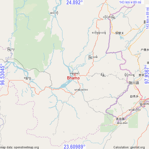
Bhamo GPS coordinates[2]
24° 15' 9.216" North, 97° 14' 0.852" East
| Map corner | latitude | longitude |
|---|---|---|
| Upper-left | 24.892°, | 96.53045° |
| Center: | 24.25256°, | 97.23357° |
| Lower-right: | 23.60989°, | 97.9367° |
| Map W x H: | 142.6×142.6 km | = 88.6×88.6mi |
| max Lat: | 25.38327° ⇑1.4% North |
| Bhamo: | 24.25256° |
| min Lat: | ⇓98.6% South 9.98238° |
| min Long | Bhamo | max Long |
| 92.89835° | 97.23357° | 99.88083° |
| W 73%⇐ | ⇒27% E |
Elevation
Elevation of Bhamo is 115 m = 377 ft, and this is 73.9 m = 242 ft below average elevation for this country.
| Max E: |
1768 m = 5801 ft | 23% |
| Avg. | 188.9 m = 620 ft | |
| Bhamo | 115 m = 377 ft | |
Min E: |
5 m = 16 ft | 77% |
See also: Bhamo elevation on elevation.city.
Geographical zone
Bhamo is located in North temperate zone (between Tropic of Cancer and the Arctic Circle). Distance of this Northern Tropic circle is 90.7 km =56.4 mi to South.| Distance of | km | miles | from Bhamo |
|---|---|---|---|
| North Pole | 7310.4 | 4542.5 | to North |
| Arctic Circle | 4704.5 | 2923.2 | to North |
| Tropic Cancer | 90.7 | 56.4 | to South |
| Equator | 2696.6 | 1675.6 | to South |


Nearby cities:
15 places around Bhamo: (largest is in red/bold)
• Falam
391.7 km =243.4 mi,  247°
247°
• Kyaukse
315.1 km =195.8 mi,  200°
200°
• Lashio
155.6 km =96.7 mi,  160°
160°
• Mandalay
279.2 km =173.5 mi, 204°
• Mawlaik
295.3 km =183.5 mi,  256°
256°
• Mogok
165.7 km =103 mi,  206°
206°
• Monywa
320.6 km =199.2 mi,  221°
221°
• Myingyan
363.5 km =225.9 mi, 211°
• Myitkyina
126.8 km =78.8 mi,  7°
7°
• Nyaungshwe
400.5 km =248.9 mi,  184°
184°
• Pakokku
392.1 km =243.6 mi, 214°
• Pyin Oo Lwin
259 km =160.9 mi, 197°
• Sagaing
293.5 km =182.4 mi, 205°
• Shwebo
244.1 km =151.7 mi, 219°
• Taunggyi
385.6 km =239.6 mi, 182°
Sources, notices
• [Note1] Compared only with cities in Myanmar existing in our database
• [Src1] Map data: © OpenStreetMap contributors (CC-BY-SA)
• [Src2] Other city data from geonames.org with taken over terms of usage.
• [Src3] Geographical zone / Annual Mean Temperature by Robert A. Rohde @ Wikipedia
