Usakos geodata
Usakos (Erongo) is a populated place; located in Namibia in Africa/Windhoek (GMT+2) time zone. With population of 9,147 people, there are 20 cities with bigger population in this country. Compared to other cities in Namibia, 54.5% of cities are located further ↑North; 77.3% of cities are located further →East and 84.1% of cities have higher elevation than Usakos. Note1


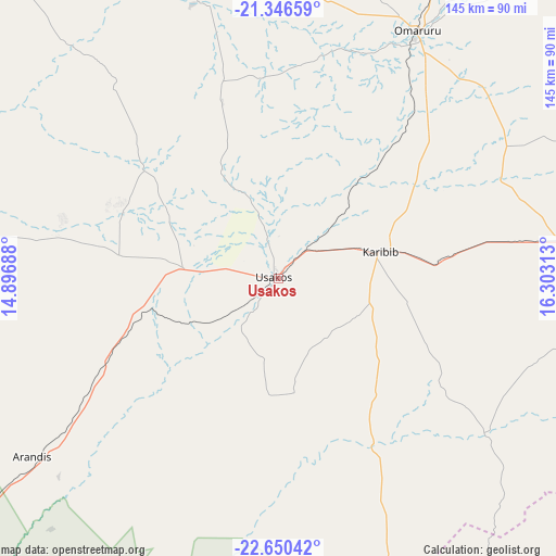
Usakos GPS coordinates[2]
22° 0' 0" South, 15° 36' 0" East
| Map corner | latitude | longitude |
|---|---|---|
| Upper-left | -21.34659°, | 14.89688° |
| Center: | -22°, | 15.6° |
| Lower-right: | -22.65042°, | 16.30313° |
| Map W x H: | 145×145 km | = 90.1×90.1mi |
| max Lat: | -17.4° ⇑54.5% North |
| Usakos: | -22° |
| min Lat: | ⇓45.5% South -28.55° |
| min Long | Usakos | max Long |
| 13.83998° | 15.6° | 24.26667° |
| W 22.7%⇐ | ⇒77.3% E |
Elevation
Elevation of Usakos is 891 m = 2923 ft, and this is 136.8 m = 449 ft below average elevation for this country.
| Max E: |
1656 m = 5433 ft | 84.1% |
| Avg. | 1027.8 m = 3372 ft | |
| Usakos | 891 m = 2923 ft | |
Min E: |
1 m = 3 ft | 15.9% |
See also: Namibia elevation on elevation.city.
Geographical zone
Usakos is located in South Torrid zone (between Equator and Tropic of Capricorn). Distance of this Southern Tropic circle is 159.7 km =99.2 mi to South.| Distance of | km | miles | from Usakos |
|---|---|---|---|
| Equator | 2446.2 | 1520 | to North |
| Tropic Capricorn | 159.7 | 99.2 | to South |
| Antarctic Circle | 4955 | 3078.9 | to South |
| South Pole | 7560.9 | 4698.1 | to South |


Nearby cities:
15 places around Usakos: (largest is in red/bold)
• Arandis
80 km =49.7 mi,  234°
234°
• Hentiesbaai
136.3 km =84.7 mi,  264°
264°
• Karibib
25.2 km =15.7 mi,  72°
72°
• Katutura
161.1 km =100.1 mi,  111°
111°
• Khorixas
193.1 km =120 mi,  340°
340°
• Okahandja
135.8 km =84.4 mi,  89°
89°
• Okakarara
246.7 km =153.3 mi,  50°
50°
• Omaruru
71.8 km =44.6 mi,  28°
28°
• Otjimbingwe
67.3 km =41.8 mi,  125°
125°
• Otjiwarongo
202.4 km =125.8 mi, 32°
• Outjo
217 km =134.8 mi,  15°
15°
• Rehoboth
211.7 km =131.5 mi, 133°
• Swakopmund
133.7 km =83.1 mi,  235°
235°
• Walvis Bay
154.9 km =96.3 mi, 226°
• Windhoek
164.8 km =102.4 mi, 112°
Sources, notices
• [Note1] Compared only with cities in Namibia existing in our database
• [Src1] Map data: © OpenStreetMap contributors (CC-BY-SA)
• [Src2] Other city data from geonames.org with taken over terms of usage.
• [Src3] Geographical zone / Annual Mean Temperature by Robert A. Rohde @ Wikipedia
