Okakarara geodata
Okakarara (Otjozondjupa) is a populated place; located in Namibia in Africa/Windhoek (GMT+2) time zone. With population of 5,255 people, there are 29 cities with bigger population in this country. Compared to other cities in Namibia, 54.5% of cities are located further ↓South; 68.2% of cities are located further ←West and 81.8% of cities have lower elevation than Okakarara. Note1


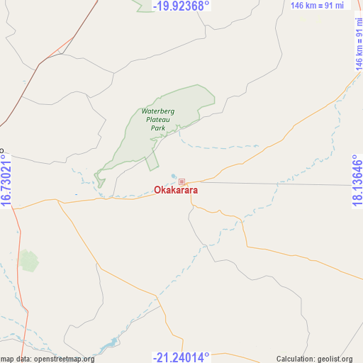
Okakarara GPS coordinates[2]
20° 34' 59.988" South, 17° 25' 59.988" East
| Map corner | latitude | longitude |
|---|---|---|
| Upper-left | -19.92368°, | 16.73021° |
| Center: | -20.58333°, | 17.43333° |
| Lower-right: | -21.24014°, | 18.13646° |
| Map W x H: | 146.4×146.4 km | = 91×91mi |
| max Lat: | -17.4° ⇑45.5% North |
| Okakarara: | -20.58333° |
| min Lat: | ⇓54.5% South -28.55° |
| min Long | Okakarara | max Long |
| 13.83998° | 17.43333° | 24.26667° |
| W 68.2%⇐ | ⇒31.8% E |
Elevation
Elevation of Okakarara is 1347 m = 4419 ft, and this is 319.2 m = 1047 ft above average elevation for this country.
| Max E: |
1656 m = 5433 ft | 18.2% |
| Okakarara | 1347 m 4419 ft | |
| Avg. | 1027.8 m = 3372 ft | |
Min E: |
1 m = 3 ft | 81.8% |
See also: Namibia elevation on elevation.city.
Geographical zone
Okakarara is located in South Torrid zone (between Equator and Tropic of Capricorn). Distance of this Southern Tropic circle is 317.3 km =197.2 mi to South.| Distance of | km | miles | from Okakarara |
|---|---|---|---|
| Equator | 2288.7 | 1422.1 | to North |
| Tropic Capricorn | 317.3 | 197.2 | to South |
| Antarctic Circle | 5112.5 | 3176.8 | to South |
| South Pole | 7718.4 | 4796 | to South |


Nearby cities:
15 places around Okakarara: (largest is in red/bold)
• Gobabis
261.2 km =162.3 mi,  142°
142°
• Grootfontein
133.7 km =83.1 mi,  32°
32°
• Karibib
223.6 km =138.9 mi,  227°
227°
• Katutura
219.1 km =136.1 mi,  190°
190°
• Khorixas
258.1 km =160.4 mi,  275°
275°
• Okahandja
164.6 km =102.3 mi,  198°
198°
• Omaruru
182.1 km =113.2 mi,  238°
238°
• Omuthiya
262.4 km =163 mi,  340°
340°
• Otavi
104.3 km =64.8 mi,  354°
354°
• Otjimbingwe
238.1 km =147.9 mi,  214°
214°
• Otjiwarongo
82.9 km =51.5 mi, 279°
• Outjo
143.5 km =89.2 mi,  291°
291°
• Tsumeb
153 km =95.1 mi,  11°
11°
• Usakos
246.7 km =153.3 mi, 230°
• Windhoek
222.7 km =138.4 mi, 189°
Sources, notices
• [Note1] Compared only with cities in Namibia existing in our database
• [Src1] Map data: © OpenStreetMap contributors (CC-BY-SA)
• [Src2] Other city data from geonames.org with taken over terms of usage.
• [Src3] Geographical zone / Annual Mean Temperature by Robert A. Rohde @ Wikipedia
