Swakopmund geodata
Swakopmund (Erongo) is a seat of a first-order administrative division; located in Namibia in Africa/Windhoek (GMT+2) time zone. With population of 25,047 people, there are 4 cities with bigger population in this country. Compared to other cities in Namibia, 70.5% of cities are located further ↑North; 93.2% of cities are located further →East and 95.5% of cities have higher elevation than Swakopmund. Note1


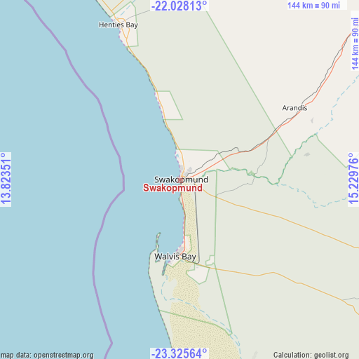
Swakopmund GPS coordinates[2]
22° 40' 42.312" South, 14° 31' 35.868" East
| Map corner | latitude | longitude |
|---|---|---|
| Upper-left | -22.02813°, | 13.82351° |
| Center: | -22.67842°, | 14.52663° |
| Lower-right: | -23.32564°, | 15.22976° |
| Map W x H: | 144.3×144.3 km | = 89.7×89.7mi |
| max Lat: | -17.4° ⇑70.5% North |
| Swakopmund: | -22.67842° |
| min Lat: | ⇓29.5% South -28.55° |
| min Long | Swakopmund | max Long |
| 13.83998° | 14.52663° | 24.26667° |
| W 6.8%⇐ | ⇒93.2% E |
Elevation
Elevation of Swakopmund is 15 m = 49 ft, and this is 1012.8 m = 3323 ft below average elevation for this country.
| Max E: |
1656 m = 5433 ft | 95.5% |
| Avg. | 1027.8 m = 3372 ft | |
| Swakopmund | 15 m = 49 ft | |
Min E: |
1 m = 3 ft | 4.5% |
See also: Namibia elevation on elevation.city.
Geographical zone
Swakopmund is located in South Torrid zone (between Equator and Tropic of Capricorn). Distance of this Southern Tropic circle is 84.3 km =52.4 mi to South.| Distance of | km | miles | from Swakopmund |
|---|---|---|---|
| Equator | 2521.6 | 1566.8 | to North |
| Tropic Capricorn | 84.3 | 52.4 | to South |
| Antarctic Circle | 4879.6 | 3032 | to South |
| South Pole | 7485.5 | 4651.3 | to South |


Nearby cities:
15 places around Swakopmund: (largest is in red/bold)
• Arandis
53.7 km =33.4 mi,  57°
57°
• Hentiesbaai
67.3 km =41.8 mi,  338°
338°
• Karibib
157.9 km =98.1 mi, 58°
• Katutura
260.7 km =162 mi,  86°
86°
• Khorixas
261 km =162.2 mi,  10°
10°
• Maltahöhe
346.3 km =215.2 mi,  133°
133°
• Okahandja
257.7 km =160.1 mi,  72°
72°
• Omaruru
200.4 km =124.5 mi,  46°
46°
• Otjimbingwe
169 km =105 mi,  77°
77°
• Otjiwarongo
329.8 km =204.9 mi,  41°
41°
• Outjo
330.7 km =205.5 mi,  30°
30°
• Rehoboth
271.8 km =168.9 mi,  105°
105°
• Usakos
133.7 km =83.1 mi, 55°
• Walvis Bay
31.1 km =19.3 mi,  184°
184°
• Windhoek
262.7 km =163.2 mi, 87°
Sources, notices
• [Note1] Compared only with cities in Namibia existing in our database
• [Src1] Map data: © OpenStreetMap contributors (CC-BY-SA)
• [Src2] Other city data from geonames.org with taken over terms of usage.
• [Src3] Geographical zone / Annual Mean Temperature by Robert A. Rohde @ Wikipedia
