Hentiesbaai geodata
Hentiesbaai (Erongo) is a populated place; located in Namibia in Africa/Windhoek (GMT+2) time zone. With population of 3,837 people, there are 34 cities with bigger population in this country. Compared to other cities in Namibia, 56.8% of cities are located further ↑North; 97.7% of cities are located further →East and 93.2% of cities have higher elevation than Hentiesbaai. Note1


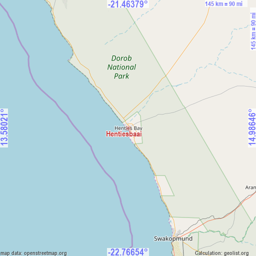
Hentiesbaai GPS coordinates[2]
22° 7' 0.012" South, 14° 16' 59.988" East
| Map corner | latitude | longitude |
|---|---|---|
| Upper-left | -21.46379°, | 13.58021° |
| Center: | -22.11667°, | 14.28333° |
| Lower-right: | -22.76654°, | 14.98646° |
| Map W x H: | 144.9×144.9 km | = 90×90mi |
| max Lat: | -17.4° ⇑56.8% North |
| Hentiesbaai: | -22.11667° |
| min Lat: | ⇓43.2% South -28.55° |
| min Long | Hentiesbaai | max Long |
| 13.83998° | 14.28333° | 24.26667° |
| W 2.3%⇐ | ⇒97.7% E |
Elevation
Elevation of Hentiesbaai is 26 m = 85 ft, and this is 1001.8 m = 3287 ft below average elevation for this country.
| Max E: |
1656 m = 5433 ft | 93.2% |
| Avg. | 1027.8 m = 3372 ft | |
| Hentiesbaai | 26 m = 85 ft | |
Min E: |
1 m = 3 ft | 6.8% |
See also: Namibia elevation on elevation.city.
Geographical zone
Hentiesbaai is located in South Torrid zone (between Equator and Tropic of Capricorn). Distance of this Southern Tropic circle is 146.8 km =91.2 mi to South.| Distance of | km | miles | from Hentiesbaai |
|---|---|---|---|
| Equator | 2459.1 | 1528 | to North |
| Tropic Capricorn | 146.8 | 91.2 | to South |
| Antarctic Circle | 4942 | 3070.8 | to South |
| South Pole | 7547.9 | 4690 | to South |


Nearby cities:
15 places around Hentiesbaai: (largest is in red/bold)
• Arandis
77.8 km =48.3 mi,  115°
115°
• Karibib
161.1 km =100.1 mi,  82°
82°
• Katutura
289.2 km =179.7 mi,  98°
98°
• Khorixas
207.1 km =128.7 mi,  19°
19°
• Okahandja
271.8 km =168.9 mi,  86°
86°
• Okakarara
368.1 km =228.7 mi,  62°
62°
• Omaruru
186.5 km =115.9 mi,  65°
65°
• Otjimbingwe
192.2 km =119.4 mi, 97°
• Otjiwarongo
306.2 km =190.3 mi,  53°
53°
• Outjo
294.8 km =183.2 mi,  41°
41°
• Rehoboth
317.3 km =197.2 mi,  114°
114°
• Swakopmund
67.3 km =41.8 mi,  158°
158°
• Usakos
136.3 km =84.7 mi, 84°
• Walvis Bay
96.2 km =59.8 mi,  166°
166°
• Windhoek
292.1 km =181.5 mi, 99°
Sources, notices
• [Note1] Compared only with cities in Namibia existing in our database
• [Src1] Map data: © OpenStreetMap contributors (CC-BY-SA)
• [Src2] Other city data from geonames.org with taken over terms of usage.
• [Src3] Geographical zone / Annual Mean Temperature by Robert A. Rohde @ Wikipedia
