Otjimbingwe geodata
Otjimbingwe (Erongo) is a populated place; located in Namibia in Africa/Windhoek (GMT+2) time zone. With population of 7,677 people, there are 23 cities with bigger population in this country. Compared to other cities in Namibia, 59.1% of cities are located further ↑North; 61.4% of cities are located further →East and 81.8% of cities have higher elevation than Otjimbingwe. Note1


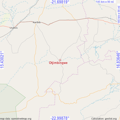
Otjimbingwe GPS coordinates[2]
22° 21' 0" South, 16° 7' 59.988" East
| Map corner | latitude | longitude |
|---|---|---|
| Upper-left | -21.69819°, | 15.43021° |
| Center: | -22.35°, | 16.13333° |
| Lower-right: | -22.99878°, | 16.83646° |
| Map W x H: | 144.6×144.6 km | = 89.9×89.9mi |
| max Lat: | -17.4° ⇑59.1% North |
| Otjimbingwe: | -22.35° |
| min Lat: | ⇓40.9% South -28.55° |
| min Long | Otjimbingwe | max Long |
| 13.83998° | 16.13333° | 24.26667° |
| W 38.6%⇐ | ⇒61.4% E |
Elevation
Elevation of Otjimbingwe is 895 m = 2936 ft, and this is 132.8 m = 436 ft below average elevation for this country.
| Max E: |
1656 m = 5433 ft | 81.8% |
| Avg. | 1027.8 m = 3372 ft | |
| Otjimbingwe | 895 m = 2936 ft | |
Min E: |
1 m = 3 ft | 18.2% |
See also: Namibia elevation on elevation.city.
Geographical zone
Otjimbingwe is located in South Torrid zone (between Equator and Tropic of Capricorn). Distance of this Southern Tropic circle is 120.8 km =75.1 mi to South.| Distance of | km | miles | from Otjimbingwe |
|---|---|---|---|
| Equator | 2485.1 | 1544.2 | to North |
| Tropic Capricorn | 120.8 | 75.1 | to South |
| Antarctic Circle | 4916.1 | 3054.7 | to South |
| South Pole | 7522 | 4674 | to South |


Nearby cities:
15 places around Otjimbingwe: (largest is in red/bold)
• Arandis
120.2 km =74.7 mi,  266°
266°
• Hentiesbaai
192.2 km =119.4 mi,  277°
277°
• Karibib
55.7 km =34.6 mi,  326°
326°
• Katutura
97.2 km =60.4 mi,  101°
101°
• Khorixas
251.4 km =156.2 mi, 331°
• Okahandja
90.4 km =56.2 mi,  63°
63°
• Okakarara
238.1 km =147.9 mi,  34°
34°
• Omaruru
104 km =64.6 mi,  348°
348°
• Otjiwarongo
216.4 km =134.5 mi,  14°
14°
• Outjo
248.3 km =154.3 mi,  0°
0°
• Rehoboth
145.5 km =90.4 mi,  137°
137°
• Swakopmund
169 km =105 mi,  257°
257°
• Usakos
67.3 km =41.8 mi,  305°
305°
• Walvis Bay
180.2 km =112 mi,  247°
247°
• Windhoek
100.3 km =62.3 mi, 103°
Sources, notices
• [Note1] Compared only with cities in Namibia existing in our database
• [Src1] Map data: © OpenStreetMap contributors (CC-BY-SA)
• [Src2] Other city data from geonames.org with taken over terms of usage.
• [Src3] Geographical zone / Annual Mean Temperature by Robert A. Rohde @ Wikipedia
