Grootfontein geodata
Grootfontein (Otjozondjupa) is a populated place; located in Namibia in Africa/Windhoek (GMT+2) time zone. With population of 24,099 people, there are 6 cities with bigger population in this country. Compared to other cities in Namibia, 65.9% of cities are located further ↓South; 79.5% of cities are located further ←West and 90.9% of cities have lower elevation than Grootfontein. Note1


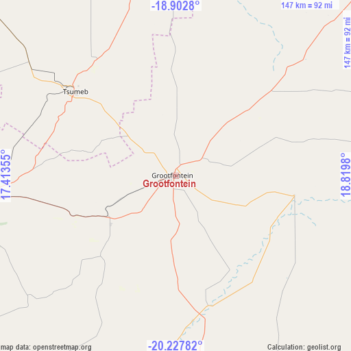
Grootfontein GPS coordinates[2]
19° 34' 0.012" South, 18° 7' 0.012" East
| Map corner | latitude | longitude |
|---|---|---|
| Upper-left | -18.9028°, | 17.41355° |
| Center: | -19.56667°, | 18.11667° |
| Lower-right: | -20.22782°, | 18.8198° |
| Map W x H: | 147.3×147.3 km | = 91.5×91.5mi |
| max Lat: | -17.4° ⇑34.1% North |
| Grootfontein: | -19.56667° |
| min Lat: | ⇓65.9% South -28.55° |
| min Long | Grootfontein | max Long |
| 13.83998° | 18.11667° | 24.26667° |
| W 79.5%⇐ | ⇒20.5% E |
Elevation
Elevation of Grootfontein is 1440 m = 4724 ft, and this is 412.2 m = 1352 ft above average elevation for this country.
| Max E: |
1656 m = 5433 ft | 9.1% |
| Grootfontein | 1440 m 4724 ft | |
| Avg. | 1027.8 m = 3372 ft | |
Min E: |
1 m = 3 ft | 90.9% |
See also: Namibia elevation on elevation.city.
Geographical zone
Grootfontein is located in South Torrid zone (between Equator and Tropic of Capricorn). Distance of this Southern Tropic circle is 430.3 km =267.4 mi to South.| Distance of | km | miles | from Grootfontein |
|---|---|---|---|
| Equator | 2175.6 | 1351.9 | to North |
| Tropic Capricorn | 430.3 | 267.4 | to South |
| Antarctic Circle | 5225.6 | 3247 | to South |
| South Pole | 7831.5 | 4866.3 | to South |


Nearby cities:
15 places around Grootfontein: (largest is in red/bold)
• Eenhana
299.8 km =186.3 mi,  321°
321°
• Gobabis
332.5 km =206.6 mi,  164°
164°
• Nkurenkuru
222.7 km =138.4 mi,  13°
13°
• Okahandja
296.2 km =184.1 mi,  204°
204°
• Okakarara
133.7 km =83.1 mi,  212°
212°
• Omaruru
307.9 km =191.3 mi,  227°
227°
• Omuthiya
209.6 km =130.2 mi,  309°
309°
• Ondangwa
292.7 km =181.9 mi, 308°
• Ongwediva
317.2 km =197.1 mi, 308°
• Oshakati
322 km =200.1 mi, 307°
• Otavi
82.6 km =51.3 mi,  263°
263°
• Otjiwarongo
183 km =113.7 mi,  236°
236°
• Outjo
214.6 km =133.3 mi,  253°
253°
• Rundu
251.3 km =156.2 mi,  43°
43°
• Tsumeb
56 km =34.8 mi, 311°
Sources, notices
• [Note1] Compared only with cities in Namibia existing in our database
• [Src1] Map data: © OpenStreetMap contributors (CC-BY-SA)
• [Src2] Other city data from geonames.org with taken over terms of usage.
• [Src3] Geographical zone / Annual Mean Temperature by Robert A. Rohde @ Wikipedia
