Tsumeb geodata
Tsumeb (Oshikoto) is a populated place; located in Namibia in Africa/Windhoek (GMT+2) time zone. With population of 12,190 people, there are 15 cities with bigger population in this country. Compared to other cities in Namibia, 68.2% of cities are located further ↓South; 70.5% of cities are located further ←West and 77.3% of cities have lower elevation than Tsumeb. Note1


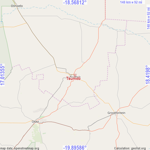
Tsumeb GPS coordinates[2]
19° 13' 59.988" South, 17° 43' 0.012" East
| Map corner | latitude | longitude |
|---|---|---|
| Upper-left | -18.56812°, | 17.01355° |
| Center: | -19.23333°, | 17.71667° |
| Lower-right: | -19.89586°, | 18.4198° |
| Map W x H: | 147.6×147.6 km | = 91.7×91.7mi |
| max Lat: | -17.4° ⇑31.8% North |
| Tsumeb: | -19.23333° |
| min Lat: | ⇓68.2% South -28.55° |
| min Long | Tsumeb | max Long |
| 13.83998° | 17.71667° | 24.26667° |
| W 70.5%⇐ | ⇒29.5% E |
Elevation
Elevation of Tsumeb is 1281 m = 4203 ft, and this is 253.2 m = 831 ft above average elevation for this country.
| Max E: |
1656 m = 5433 ft | 22.7% |
| Tsumeb | 1281 m 4203 ft | |
| Avg. | 1027.8 m = 3372 ft | |
Min E: |
1 m = 3 ft | 77.3% |
See also: Namibia elevation on elevation.city.
Geographical zone
Tsumeb is located in South Torrid zone (between Equator and Tropic of Capricorn). Distance of this Southern Tropic circle is 467.4 km =290.4 mi to South.| Distance of | km | miles | from Tsumeb |
|---|---|---|---|
| Equator | 2138.5 | 1328.8 | to North |
| Tropic Capricorn | 467.4 | 290.4 | to South |
| Antarctic Circle | 5262.6 | 3270 | to South |
| South Pole | 7868.5 | 4889.3 | to South |


Nearby cities:
15 places around Tsumeb: (largest is in red/bold)
• Eenhana
244.7 km =152 mi,  323°
323°
• Grootfontein
56 km =34.8 mi,  131°
131°
• Khorixas
314.1 km =195.2 mi,  246°
246°
• Nkurenkuru
202.5 km =125.8 mi,  27°
27°
• Okakarara
153 km =95.1 mi,  191°
191°
• Omaruru
307.2 km =190.9 mi,  217°
217°
• Omuthiya
153.6 km =95.4 mi,  308°
308°
• Ondangwa
236.9 km =147.2 mi, 308°
• Ongwediva
261.3 km =162.4 mi, 308°
• Oshakati
266.1 km =165.3 mi, 307°
• Oshikango
281.1 km =174.7 mi, 316°
• Otavi
61.3 km =38.1 mi, 220°
• Otjiwarongo
176.7 km =109.8 mi, 219°
• Outjo
191.2 km =118.8 mi,  239°
239°
• Rundu
259.9 km =161.5 mi,  56°
56°
Sources, notices
• [Note1] Compared only with cities in Namibia existing in our database
• [Src1] Map data: © OpenStreetMap contributors (CC-BY-SA)
• [Src2] Other city data from geonames.org with taken over terms of usage.
• [Src3] Geographical zone / Annual Mean Temperature by Robert A. Rohde @ Wikipedia
