Gobabis geodata
Gobabis (Omaheke) is a seat of a first-order administrative division; located in Namibia in Africa/Windhoek (GMT+2) time zone. With population of 16,321 people, there are 11 cities with bigger population in this country. Compared to other cities in Namibia, 63.6% of cities are located further ↑North; 90.9% of cities are located further ←West and 93.2% of cities have lower elevation than Gobabis. Note1


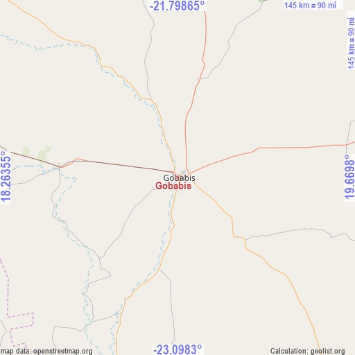
Gobabis GPS coordinates[2]
22° 27' 0" South, 18° 58' 0.012" East
| Map corner | latitude | longitude |
|---|---|---|
| Upper-left | -21.79865°, | 18.26355° |
| Center: | -22.45°, | 18.96667° |
| Lower-right: | -23.0983°, | 19.6698° |
| Map W x H: | 144.5×144.5 km | = 89.8×89.8mi |
| max Lat: | -17.4° ⇑63.6% North |
| Gobabis: | -22.45° |
| min Lat: | ⇓36.4% South -28.55° |
| min Long | Gobabis | max Long |
| 13.83998° | 18.96667° | 24.26667° |
| W 90.9%⇐ | ⇒9.1% E |
Elevation
Elevation of Gobabis is 1442 m = 4731 ft, and this is 414.2 m = 1359 ft above average elevation for this country.
| Max E: |
1656 m = 5433 ft | 6.8% |
| Gobabis | 1442 m 4731 ft | |
| Avg. | 1027.8 m = 3372 ft | |
Min E: |
1 m = 3 ft | 93.2% |
See also: Namibia elevation on elevation.city.
Geographical zone
Gobabis is located in South Torrid zone (between Equator and Tropic of Capricorn). Distance of this Southern Tropic circle is 109.7 km =68.2 mi to South.| Distance of | km | miles | from Gobabis |
|---|---|---|---|
| Equator | 2496.2 | 1551.1 | to North |
| Tropic Capricorn | 109.7 | 68.2 | to South |
| Antarctic Circle | 4905 | 3047.8 | to South |
| South Pole | 7510.9 | 4667.1 | to South |


Nearby cities:
15 places around Gobabis: (largest is in red/bold)
• Aranos
187.8 km =116.7 mi,  175°
175°
• Grootfontein
332.5 km =206.6 mi,  344°
344°
• Hoachanas
188.1 km =116.9 mi,  209°
209°
• Karibib
327.7 km =203.6 mi,  280°
280°
• Katutura
196 km =121.8 mi,  267°
267°
• Maltahöhe
333.2 km =207 mi,  217°
217°
• Mariental
263.3 km =163.6 mi,  202°
202°
• Okahandja
217.3 km =135 mi, 283°
• Okakarara
261.2 km =162.3 mi,  322°
322°
• Omaruru
332.6 km =206.7 mi,  289°
289°
• Otjimbingwe
291.5 km =181.1 mi, 272°
• Otjiwarongo
326.1 km =202.6 mi,  312°
312°
• Rehoboth
215.1 km =133.7 mi,  243°
243°
• Usakos
350.1 km =217.5 mi, 278°
• Windhoek
193.9 km =120.5 mi, 266°
Sources, notices
• [Note1] Compared only with cities in Namibia existing in our database
• [Src1] Map data: © OpenStreetMap contributors (CC-BY-SA)
• [Src2] Other city data from geonames.org with taken over terms of usage.
• [Src3] Geographical zone / Annual Mean Temperature by Robert A. Rohde @ Wikipedia
