Aranos geodata
Aranos (Hardap) is a populated place; located in Namibia in Africa/Windhoek (GMT+2) time zone. With population of 3,430 people, there are 35 cities with bigger population in this country. Compared to other cities in Namibia, 79.5% of cities are located further ↑North; 93.2% of cities are located further ←West and 68.2% of cities have lower elevation than Aranos. Note1


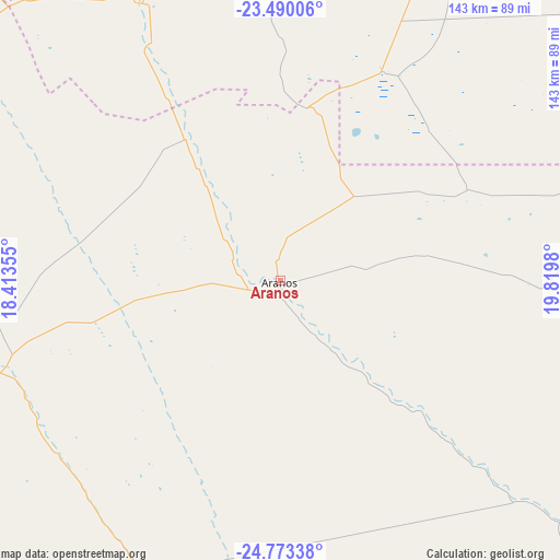
Aranos GPS coordinates[2]
24° 7' 59.988" South, 19° 7' 0.012" East
| Map corner | latitude | longitude |
|---|---|---|
| Upper-left | -23.49006°, | 18.41355° |
| Center: | -24.13333°, | 19.11667° |
| Lower-right: | -24.77338°, | 19.8198° |
| Map W x H: | 142.7×142.7 km | = 88.7×88.7mi |
| max Lat: | -17.4° ⇑79.5% North |
| Aranos: | -24.13333° |
| min Lat: | ⇓20.5% South -28.55° |
| min Long | Aranos | max Long |
| 13.83998° | 19.11667° | 24.26667° |
| W 93.2%⇐ | ⇒6.8% E |
Elevation
Elevation of Aranos is 1193 m = 3914 ft, and this is 165.2 m = 542 ft above average elevation for this country.
| Max E: |
1656 m = 5433 ft | 31.8% |
| Aranos | 1193 m 3914 ft | |
| Avg. | 1027.8 m = 3372 ft | |
Min E: |
1 m = 3 ft | 68.2% |
See also: Namibia elevation on elevation.city.
Geographical zone
Aranos is located in South temperate zone (between Tropic of Capricorn and the Antarctic Circle). Distance of this Southern Tropic circle is 77.5 km =48.2 mi to North.| Distance of | km | miles | from Aranos |
|---|---|---|---|
| Equator | 2683.4 | 1667.4 | to North |
| Tropic Capricorn | 77.5 | 48.2 | to North |
| Antarctic Circle | 4717.8 | 2931.5 | to South |
| South Pole | 7323.7 | 4550.7 | to South |


Nearby cities:
15 places around Aranos: (largest is in red/bold)
• Bethanie
327.6 km =203.6 mi,  217°
217°
• Gobabis
187.8 km =116.7 mi,  355°
355°
• Hoachanas
111 km =69 mi,  282°
282°
• Karasburg
433.3 km =269.2 mi,  184°
184°
• Karibib
415.6 km =258.2 mi,  306°
306°
• Katutura
275.9 km =171.4 mi, 310°
• Keetmanshoop
289.8 km =180.1 mi,  199°
199°
• Maltahöhe
229.5 km =142.6 mi,  250°
250°
• Mariental
129.1 km =80.2 mi,  244°
244°
• Okahandja
328.3 km =204 mi,  316°
316°
• Okakarara
431 km =267.8 mi,  336°
336°
• Otjimbingwe
363.6 km =225.9 mi,  303°
303°
• Rehoboth
225.4 km =140.1 mi,  293°
293°
• Tses
224.8 km =139.7 mi,  210°
210°
• Windhoek
271.5 km =168.7 mi, 310°
Sources, notices
• [Note1] Compared only with cities in Namibia existing in our database
• [Src1] Map data: © OpenStreetMap contributors (CC-BY-SA)
• [Src2] Other city data from geonames.org with taken over terms of usage.
• [Src3] Geographical zone / Annual Mean Temperature by Robert A. Rohde @ Wikipedia
