Dadeldhurā geodata
Dadeldhurā (Far Western) is a populated place; located in Nepal in Asia/Kathmandu (GMT+5.75) time zone. With population of 19,014 people, there are 39 cities with bigger population in this country. Compared to other cities in Nepal, 94.6% of cities are located further ↓South; 97.3% of cities are located further →East and 82.4% of cities have lower elevation than Dadeldhurā. Note1


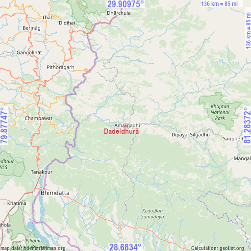
Dadeldhurā GPS coordinates[2]
29° 17' 54.312" North, 80° 34' 50.124" East
| Map corner | latitude | longitude |
|---|---|---|
| Upper-left | 29.90975°, | 79.87747° |
| Center: | 29.29842°, | 80.58059° |
| Lower-right: | 28.6834°, | 81.28372° |
| Map W x H: | 136.4×136.4 km | = 84.8×84.8mi |
| max Lat: | 30.04651° ⇑5.4% North |
| Dadeldhurā: | 29.29842° |
| min Lat: | ⇓94.6% South 26.45505° |
| min Long | Dadeldhurā | max Long |
| 80.17715° | 80.58059° | 88.09436° |
| W 2.7%⇐ | ⇒97.3% E |
Elevation
Elevation of Dadeldhurā is 1814 m = 5951 ft, and this is 638.8 m = 2096 ft above average elevation for this country.
| Max E: |
5251 m = 17228 ft | 17.6% |
| Dadeldhurā | 1814 m 5951 ft | |
| Avg. | 1175.2 m = 3856 ft | |
Min E: |
72 m = 236 ft | 82.4% |
See also: Nepal elevation on elevation.city.
Geographical zone
Dadeldhurā is located in North temperate zone (between Tropic of Cancer and the Arctic Circle). Distance of this Northern Tropic circle is 651.8 km =405 mi to South.| Distance of | km | miles | from Dadeldhurā |
|---|---|---|---|
| North Pole | 6749.4 | 4193.9 | to North |
| Arctic Circle | 4143.5 | 2574.7 | to North |
| Tropic Cancer | 651.8 | 405 | to South |
| Equator | 3257.7 | 2024.2 | to South |


Nearby cities:
15 places around Dadeldhurā: (largest is in red/bold)
• Achhām
75.1 km =46.7 mi,  111°
111°
• Bardiyā
134.1 km =83.3 mi,  145°
145°
• Birendranagar
128.4 km =79.8 mi,  127°
127°
• Chhibro
140.4 km =87.2 mi,  60°
60°
• Dailekh
120.8 km =75.1 mi, 114°
• Dhangaḍhi̇̄
66.4 km =41.3 mi,  179°
179°
• Dipayal
35.1 km =21.8 mi,  96°
96°
• Dārchulā
59.2 km =36.8 mi,  357°
357°
• Gulariyā
142.5 km =88.5 mi, 148°
• Jumla
155.5 km =96.6 mi,  90°
90°
• Mahendranagar
54 km =33.6 mi,  226°
226°
• Nepalgunj
171.7 km =106.7 mi,  143°
143°
• Simikot
141.5 km =87.9 mi, 58°
• Surkhet
145.4 km =90.3 mi, 126°
• Ṭikāpur
100.3 km =62.3 mi, 148°
Sources, notices
• [Note1] Compared only with cities in Nepal existing in our database
• [Src1] Map data: © OpenStreetMap contributors (CC-BY-SA)
• [Src2] Other city data from geonames.org with taken over terms of usage.
• [Src3] Geographical zone / Annual Mean Temperature by Robert A. Rohde @ Wikipedia
