Chhibro geodata
Chhibro is a populated place; located in Nepal in Asia/Kathmandu (GMT+5.75) time zone. With population of 777 people, there are 59 cities with bigger population in this country. Compared to other cities in Nepal, 97.3% of cities are located further ↓South; 79.7% of cities are located further →East and 91.9% of cities have lower elevation than Chhibro. Note1


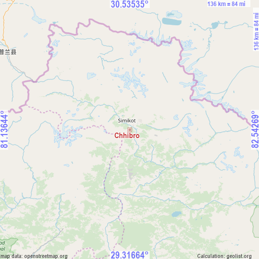
Chhibro GPS coordinates[2]
29° 55' 40.296" North, 81° 50' 22.416" East
| Map corner | latitude | longitude |
|---|---|---|
| Upper-left | 30.53535°, | 81.13644° |
| Center: | 29.92786°, | 81.83956° |
| Lower-right: | 29.31664°, | 82.54269° |
| Map W x H: | 135.5×135.5 km | = 84.2×84.2mi |
| max Lat: | 30.04651° ⇑2.7% North |
| Chhibro: | 29.92786° |
| min Lat: | ⇓97.3% South 26.45505° |
| min Long | Chhibro | max Long |
| 80.17715° | 81.83956° | 88.09436° |
| W 20.3%⇐ | ⇒79.7% E |
Elevation
Elevation of Chhibro is 2879 m = 9446 ft, and this is 1703.8 m = 5590 ft above average elevation for this country.
| Max E: |
5251 m = 17228 ft | 8.1% |
| Chhibro | 2879 m 9446 ft | |
| Avg. | 1175.2 m = 3856 ft | |
Min E: |
72 m = 236 ft | 91.9% |
See also: Nepal elevation on elevation.city.
Geographical zone
Chhibro is located in North temperate zone (between Tropic of Cancer and the Arctic Circle). Distance of this Northern Tropic circle is 721.7 km =448.4 mi to South.| Distance of | km | miles | from Chhibro |
|---|---|---|---|
| North Pole | 6679.4 | 4150.4 | to North |
| Arctic Circle | 4073.5 | 2531.2 | to North |
| Tropic Cancer | 721.7 | 448.4 | to South |
| Equator | 3327.7 | 2067.7 | to South |


Nearby cities:
15 places around Chhibro: (largest is in red/bold)
• Achhām
110.7 km =68.8 mi,  208°
208°
• Bardiyā
187 km =116.2 mi,  194°
194°
• Birendranagar
148.8 km =92.5 mi, 187°
• Dadeldhurā
140.4 km =87.2 mi,  240°
240°
• Dailekh
121.1 km =75.2 mi, 185°
• Dhangaḍhi̇̄
182.4 km =113.3 mi,  221°
221°
• Dipayal
114.3 km =71 mi,  229°
229°
• Dārchulā
124.8 km =77.5 mi,  264°
264°
• Jumla
79.9 km =49.6 mi,  155°
155°
• Khārpū
33.3 km =20.7 mi,  66°
66°
• Mahendranagar
193.4 km =120.2 mi, 236°
• Salyān
175.2 km =108.9 mi,  169°
169°
• Simikot
4.4 km =2.7 mi,  344°
344°
• Surkhet
156.9 km =97.5 mi,  182°
182°
• Ṭikāpur
170.6 km =106 mi,  204°
204°
Sources, notices
• [Note1] Compared only with cities in Nepal existing in our database
• [Src1] Map data: © OpenStreetMap contributors (CC-BY-SA)
• [Src2] Other city data from geonames.org with taken over terms of usage.
• [Src3] Geographical zone / Annual Mean Temperature by Robert A. Rohde @ Wikipedia
