Abu Jibeha geodata
Abu Jibeha (Southern Kordofan) is a populated place; located in Sudan in Africa/Khartoum (GMT+2) time zone. With population of 21,790 people, there are 38 cities with bigger population in this country. Compared to other cities in Sudan, 91.5% of cities are located further ↑North; 64.8% of cities are located further →East and 83.1% of cities have lower elevation than Abu Jibeha. Note1


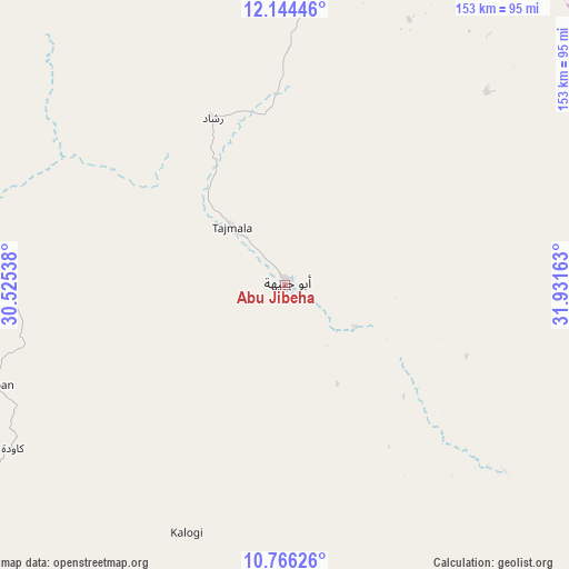
Abu Jibeha GPS coordinates[2]
11° 27' 22.32" North, 31° 13' 42.6" East
| Map corner | latitude | longitude |
|---|---|---|
| Upper-left | 12.14446°, | 30.52538° |
| Center: | 11.4562°, | 31.2285° |
| Lower-right: | 10.76626°, | 31.93163° |
| Map W x H: | 153.2×153.2 km | = 95.2×95.2mi |
| max Lat: | 21.06667° ⇑91.5% North |
| Abu Jibeha: | 11.4562° |
| min Lat: | ⇓8.5% South 10.55° |
| min Long | Abu Jibeha | max Long |
| 22.44725° | 31.2285° | 37.729° |
| W 35.2%⇐ | ⇒64.8% E |
Elevation
Elevation of Abu Jibeha is 573 m = 1880 ft, and this is 123.9 m = 406 ft above average elevation for this country.
| Max E: |
1159 m = 3802 ft | 16.9% |
| Abu Jibeha | 573 m 1880 ft | |
| Avg. | 449.1 m = 1473 ft | |
Min E: |
4 m = 13 ft | 83.1% |
See also: Sudan elevation on elevation.city.
Geographical zone
Abu Jibeha is located in North Torrid zone (between Equator and Tropic of Cancer). Distance of Equator is 1273.8 km =791.5 mi to South.| Distance of | km | miles | from Abu Jibeha |
|---|---|---|---|
| North Pole | 8733.3 | 5426.6 | to North |
| Arctic Circle | 6127.4 | 3807.4 | to North |
| Tropic Cancer | 1332.1 | 827.7 | to North |
| Equator | 1273.8 | 791.5 | to South |


Nearby cities:
15 places around Abu Jibeha: (largest is in red/bold)
• Abū Zabad
237.1 km =147.3 mi,  294°
294°
• Al Kawa
289.6 km =179.9 mi,  28°
28°
• Al Lagowa
228.4 km =141.9 mi,  268°
268°
• Ar Rahad
153.6 km =95.4 mi,  335°
335°
• Bārah
266.4 km =165.5 mi, 339°
• Dilling
184.1 km =114.4 mi, 291°
• El Obeid
221.4 km =137.6 mi,  330°
330°
• Kadugli
172 km =106.9 mi,  253°
253°
• Kosti
245.6 km =152.6 mi,  39°
39°
• Marabba
143.8 km =89.4 mi,  46°
46°
• Rabak
252.4 km =156.8 mi, 40°
• Talodi
130.3 km =81 mi,  225°
225°
• Tandaltī
186.9 km =116.1 mi,  21°
21°
• Um Jar Al Gharbiyya
290.4 km =180.4 mi, 26°
• Umm Ruwaba
161.2 km =100.2 mi,  359°
359°
Sources, notices
• [Note1] Compared only with cities in Sudan existing in our database
• [Src1] Map data: © OpenStreetMap contributors (CC-BY-SA)
• [Src2] Other city data from geonames.org with taken over terms of usage.
• [Src3] Geographical zone / Annual Mean Temperature by Robert A. Rohde @ Wikipedia
