Talodi geodata
Talodi (Southern Kordofan) is a populated place; located in Sudan in Africa/Khartoum (GMT+2) time zone. With population of 13,188 people, there are 49 cities with bigger population in this country. Compared to other cities in Sudan, 98.6% of cities are located further ↑North; 74.6% of cities are located further →East and 69% of cities have lower elevation than Talodi. Note1


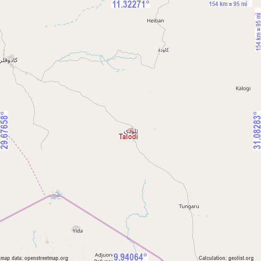
Talodi GPS coordinates[2]
10° 37' 56.856" North, 30° 22' 46.92" East
| Map corner | latitude | longitude |
|---|---|---|
| Upper-left | 11.32271°, | 29.67658° |
| Center: | 10.63246°, | 30.3797° |
| Lower-right: | 9.94064°, | 31.08283° |
| Map W x H: | 153.7×153.7 km | = 95.5×95.5mi |
| max Lat: | 21.06667° ⇑98.6% North |
| Talodi: | 10.63246° |
| min Lat: | ⇓1.4% South 10.55° |
| min Long | Talodi | max Long |
| 22.44725° | 30.3797° | 37.729° |
| W 25.4%⇐ | ⇒74.6% E |
Elevation
Elevation of Talodi is 485 m = 1591 ft, and this is 35.9 m = 118 ft above average elevation for this country.
| Max E: |
1159 m = 3802 ft | 31% |
| Talodi | 485 m 1591 ft | |
| Avg. | 449.1 m = 1473 ft | |
Min E: |
4 m = 13 ft | 69% |
See also: Sudan elevation on elevation.city.
Geographical zone
Talodi is located in North Torrid zone (between Equator and Tropic of Cancer). Distance of Equator is 1182.2 km =734.6 mi to South.| Distance of | km | miles | from Talodi |
|---|---|---|---|
| North Pole | 8824.8 | 5483.5 | to North |
| Arctic Circle | 6219 | 3864.3 | to North |
| Tropic Cancer | 1423.7 | 884.6 | to North |
| Equator | 1182.2 | 734.6 | to South |


Nearby cities:
15 places around Talodi: (largest is in red/bold)
• Abu Jibeha
130.3 km =81 mi,  45°
45°
• Abū Zabad
227.2 km =141.2 mi,  327°
327°
• Al Fūlah
252.2 km =156.7 mi,  299°
299°
• Al Lagowa
160.6 km =99.8 mi, 302°
• Al Mijlad
292.4 km =181.7 mi,  278°
278°
• An Nuhūd
312.7 km =194.3 mi,  317°
317°
• Ar Rahad
233.6 km =145.2 mi,  7°
7°
• Bārah
341.1 km =211.9 mi,  359°
359°
• Dilling
176.6 km =109.7 mi, 333°
• El Fula
252.2 km =156.7 mi, 298°
• El Obeid
284.3 km =176.7 mi, 356°
• Kadugli
83.6 km =51.9 mi, 300°
• Marabba
274 km =170.3 mi, 45°
• Tandaltī
310.6 km =193 mi,  31°
31°
• Umm Ruwaba
268.7 km =167 mi,  19°
19°
Sources, notices
• [Note1] Compared only with cities in Sudan existing in our database
• [Src1] Map data: © OpenStreetMap contributors (CC-BY-SA)
• [Src2] Other city data from geonames.org with taken over terms of usage.
• [Src3] Geographical zone / Annual Mean Temperature by Robert A. Rohde @ Wikipedia
