Dhuusamarreeb geodata
Dhuusamarreeb (Galguduud) is a seat of a first-order administrative division; located in Somalia in Africa/Mogadishu (GMT+3) time zone. With population of 9,000 people, there are 34 cities with bigger population in this country. Compared to other cities in Somalia, 58.5% of cities are located further ↓South; 66% of cities are located further ←West and 66% of cities have lower elevation than Dhuusamarreeb. Note1


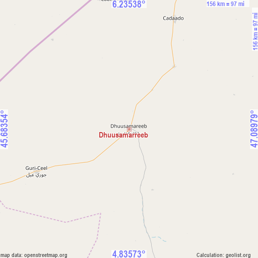
Dhuusamarreeb GPS coordinates[2]
5° 32' 9.492" North, 46° 23' 11.976" East
| Map corner | latitude | longitude |
|---|---|---|
| Upper-left | 6.23538°, | 45.68354° |
| Center: | 5.53597°, | 46.38666° |
| Lower-right: | 4.83573°, | 47.08979° |
| Map W x H: | 155.6×155.6 km | = 96.7×96.7mi |
| max Lat: | 11.96611° ⇑41.5% North |
| Dhuusamarreeb: | 5.53597° |
| min Lat: | ⇓58.5% South -1.21917° |
| min Long | Dhuusamarreeb | max Long |
| 41.83725° | 46.38666° | 51.0773° |
| W 66%⇐ | ⇒34% E |
Elevation
Elevation of Dhuusamarreeb is 254 m = 833 ft, and this is 35.9 m = 118 ft below average elevation for this country.
| Max E: |
1786 m = 5860 ft | 34% |
| Avg. | 289.9 m = 951 ft | |
| Dhuusamarreeb | 254 m = 833 ft | |
Min E: |
-2 m = -7 ft | 66% |
See also: Somalia elevation on elevation.city.
Geographical zone
Dhuusamarreeb is located in North Torrid zone (between Equator and Tropic of Cancer). Distance of Equator is 615.5 km =382.5 mi to South.| Distance of | km | miles | from Dhuusamarreeb |
|---|---|---|---|
| North Pole | 9391.5 | 5835.6 | to North |
| Arctic Circle | 6785.6 | 4216.4 | to North |
| Tropic Cancer | 1990.4 | 1236.8 | to North |
| Equator | 615.5 | 382.5 | to South |


Nearby cities:
15 places around Dhuusamarreeb: (largest is in red/bold)
• Adado
71.8 km =44.6 mi,  21°
21°
• Beledweyne
158.4 km =98.4 mi,  235°
235°
• Buulobarde
207.9 km =129.2 mi,  205°
205°
• Cadale
308.7 km =191.8 mi,  181°
181°
• Ceelbuur
98 km =60.9 mi,  164°
164°
• Ceeldheer
207.2 km =128.7 mi,  154°
154°
• Gaalkacyo
179.3 km =111.4 mi,  40°
40°
• Hobyo
237.8 km =147.8 mi,  94°
94°
• Jalalaqsi
255.5 km =158.8 mi,  199°
199°
• Jawhar
321.7 km =199.9 mi, 197°
• Laascaanood
344.2 km =213.9 mi, 18°
• Mahaddayweyne
300.3 km =186.6 mi, 198°
• Tayeeglow
267.6 km =166.3 mi,  230°
230°
• Xarardheere
190.1 km =118.1 mi,  121°
121°
• Xuddur
318.3 km =197.8 mi, 240°
Sources, notices
• [Note1] Compared only with cities in Somalia existing in our database
• [Src1] Map data: © OpenStreetMap contributors (CC-BY-SA)
• [Src2] Other city data from geonames.org with taken over terms of usage.
• [Src3] Geographical zone / Annual Mean Temperature by Robert A. Rohde @ Wikipedia
