Buulobarde geodata
Buulobarde (Hiiraan) is a populated place; located in Somalia in Africa/Mogadishu (GMT+3) time zone. With population of 16,928 people, there are 25 cities with bigger population in this country. Compared to other cities in Somalia, 56.6% of cities are located further ↑North; 60.4% of cities are located further ←West and 54.7% of cities have lower elevation than Buulobarde. Note1


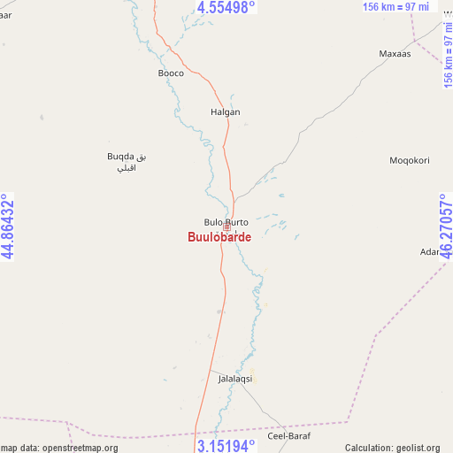
Buulobarde GPS coordinates[2]
3° 51' 13.5" North, 45° 34' 2.784" East
| Map corner | latitude | longitude |
|---|---|---|
| Upper-left | 4.55498°, | 44.86432° |
| Center: | 3.85375°, | 45.56744° |
| Lower-right: | 3.15194°, | 46.27057° |
| Map W x H: | 156×156 km | = 96.9×96.9mi |
| max Lat: | 11.96611° ⇑56.6% North |
| Buulobarde: | 3.85375° |
| min Lat: | ⇓43.4% South -1.21917° |
| min Long | Buulobarde | max Long |
| 41.83725° | 45.56744° | 51.0773° |
| W 60.4%⇐ | ⇒39.6% E |
Elevation
Elevation of Buulobarde is 150 m = 492 ft, and this is 139.9 m = 459 ft below average elevation for this country.
| Max E: |
1786 m = 5860 ft | 45.3% |
| Avg. | 289.9 m = 951 ft | |
| Buulobarde | 150 m = 492 ft | |
Min E: |
-2 m = -7 ft | 54.7% |
See also: Somalia elevation on elevation.city.
Geographical zone
Buulobarde is located in North Torrid zone (between Equator and Tropic of Cancer). Distance of Equator is 428.5 km =266.3 mi to South.| Distance of | km | miles | from Buulobarde |
|---|---|---|---|
| North Pole | 9578.6 | 5951.9 | to North |
| Arctic Circle | 6972.7 | 4332.6 | to North |
| Tropic Cancer | 2177.4 | 1353 | to North |
| Equator | 428.5 | 266.3 | to South |


Nearby cities:
15 places around Buulobarde: (largest is in red/bold)
• Afgooye
197.1 km =122.5 mi,  194°
194°
• Baidoa
228.2 km =141.8 mi,  248°
248°
• Beledweyne
106.1 km =65.9 mi,  337°
337°
• Buurhakaba
202.5 km =125.8 mi,  234°
234°
• Cadale
147.7 km =91.8 mi,  145°
145°
• Ceelbuur
148.7 km =92.4 mi,  51°
51°
• Ceeldheer
179 km =111.2 mi,  90°
90°
• Dhuusamarreeb
207.9 km =129.2 mi,  25°
25°
• Jalalaqsi
53.2 km =33.1 mi,  176°
176°
• Jawhar
119.5 km =74.3 mi, 183°
• Mahaddayweyne
98 km =60.9 mi, 182°
• Mogadishu
203.5 km =126.4 mi, 187°
• Tayeeglow
118.6 km =73.7 mi,  278°
278°
• Wanlaweyn
156.4 km =97.2 mi,  208°
208°
• Xuddur
188.5 km =117.1 mi, 279°
Sources, notices
• [Note1] Compared only with cities in Somalia existing in our database
• [Src1] Map data: © OpenStreetMap contributors (CC-BY-SA)
• [Src2] Other city data from geonames.org with taken over terms of usage.
• [Src3] Geographical zone / Annual Mean Temperature by Robert A. Rohde @ Wikipedia
