Ceelbuur geodata
Ceelbuur (Galguduud) is a populated place; located in Somalia in Africa/Mogadishu (GMT+3) time zone. With population of 9,031 people, there are 33 cities with bigger population in this country. Compared to other cities in Somalia, 52.8% of cities are located further ↓South; 67.9% of cities are located further ←West and 58.5% of cities have lower elevation than Ceelbuur. Note1


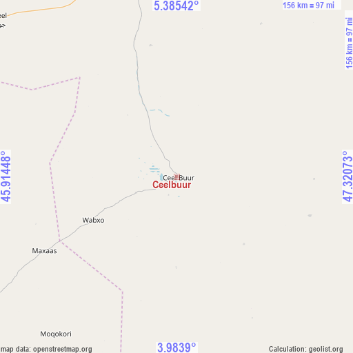
Ceelbuur GPS coordinates[2]
4° 41' 6.036" North, 46° 37' 3.36" East
| Map corner | latitude | longitude |
|---|---|---|
| Upper-left | 5.38542°, | 45.91448° |
| Center: | 4.68501°, | 46.6176° |
| Lower-right: | 3.9839°, | 47.32073° |
| Map W x H: | 155.8×155.8 km | = 96.8×96.8mi |
| max Lat: | 11.96611° ⇑47.2% North |
| Ceelbuur: | 4.68501° |
| min Lat: | ⇓52.8% South -1.21917° |
| min Long | Ceelbuur | max Long |
| 41.83725° | 46.6176° | 51.0773° |
| W 67.9%⇐ | ⇒32.1% E |
Elevation
Elevation of Ceelbuur is 153 m = 502 ft, and this is 136.9 m = 449 ft below average elevation for this country.
| Max E: |
1786 m = 5860 ft | 41.5% |
| Avg. | 289.9 m = 951 ft | |
| Ceelbuur | 153 m = 502 ft | |
Min E: |
-2 m = -7 ft | 58.5% |
See also: Somalia elevation on elevation.city.
Geographical zone
Ceelbuur is located in North Torrid zone (between Equator and Tropic of Cancer). Distance of Equator is 520.9 km =323.7 mi to South.| Distance of | km | miles | from Ceelbuur |
|---|---|---|---|
| North Pole | 9486.1 | 5894.4 | to North |
| Arctic Circle | 6880.2 | 4275.2 | to North |
| Tropic Cancer | 2085 | 1295.6 | to North |
| Equator | 520.9 | 323.7 | to South |


Nearby cities:
15 places around Ceelbuur: (largest is in red/bold)
• Adado
161.3 km =100.2 mi,  0°
0°
• Beledweyne
156.8 km =97.4 mi,  272°
272°
• Buulobarde
148.7 km =92.4 mi,  231°
231°
• Cadale
216.5 km =134.5 mi,  188°
188°
• Ceeldheer
112 km =69.6 mi,  146°
146°
• Dhuusamarreeb
98 km =60.9 mi,  344°
344°
• Gaalkacyo
248.6 km =154.5 mi,  21°
21°
• Hobyo
224 km =139.2 mi,  70°
70°
• Jalalaqsi
184.2 km =114.5 mi,  217°
217°
• Jawhar
245.3 km =152.4 mi,  210°
210°
• Mahaddayweyne
225.1 km =139.9 mi, 212°
• Tayeeglow
245 km =152.2 mi,  252°
252°
• Wanlaweyn
299 km =185.8 mi, 219°
• Xarardheere
137.4 km =85.4 mi,  91°
91°
• Xuddur
308.9 km =191.9 mi,  258°
258°
Sources, notices
• [Note1] Compared only with cities in Somalia existing in our database
• [Src1] Map data: © OpenStreetMap contributors (CC-BY-SA)
• [Src2] Other city data from geonames.org with taken over terms of usage.
• [Src3] Geographical zone / Annual Mean Temperature by Robert A. Rohde @ Wikipedia
