Jalalaqsi geodata
Jalalaqsi (Hiiraan) is a populated place; located in Somalia in Africa/Mogadishu (GMT+3) time zone. With population of 9,743 people, there are 32 cities with bigger population in this country. Compared to other cities in Somalia, 64.2% of cities are located further ↑North; 62.3% of cities are located further ←West and 52.8% of cities have lower elevation than Jalalaqsi. Note1


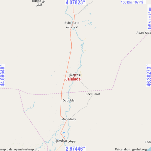
Jalalaqsi GPS coordinates[2]
3° 22' 35.76" North, 45° 35' 58.56" East
| Map corner | latitude | longitude |
|---|---|---|
| Upper-left | 4.07823°, | 44.89648° |
| Center: | 3.3766°, | 45.5996° |
| Lower-right: | 2.67446°, | 46.30273° |
| Map W x H: | 156.1×156.1 km | = 97×97mi |
| max Lat: | 11.96611° ⇑64.2% North |
| Jalalaqsi: | 3.3766° |
| min Lat: | ⇓35.8% South -1.21917° |
| min Long | Jalalaqsi | max Long |
| 41.83725° | 45.5996° | 51.0773° |
| W 62.3%⇐ | ⇒37.7% E |
Elevation
Elevation of Jalalaqsi is 129 m = 423 ft, and this is 160.9 m = 528 ft below average elevation for this country.
| Max E: |
1786 m = 5860 ft | 47.2% |
| Avg. | 289.9 m = 951 ft | |
| Jalalaqsi | 129 m = 423 ft | |
Min E: |
-2 m = -7 ft | 52.8% |
See also: Somalia elevation on elevation.city.
Geographical zone
Jalalaqsi is located in North Torrid zone (between Equator and Tropic of Cancer). Distance of Equator is 375.4 km =233.3 mi to South.| Distance of | km | miles | from Jalalaqsi |
|---|---|---|---|
| North Pole | 9631.6 | 5984.8 | to North |
| Arctic Circle | 7025.7 | 4365.6 | to North |
| Tropic Cancer | 2230.5 | 1386 | to North |
| Equator | 375.4 | 233.3 | to South |


Nearby cities:
15 places around Jalalaqsi: (largest is in red/bold)
• Afgooye
147.6 km =91.7 mi,  201°
201°
• Beledweyne
157.4 km =97.8 mi,  343°
343°
• Buulobarde
53.2 km =33.1 mi,  356°
356°
• Buurhakaba
180.6 km =112.2 mi,  249°
249°
• Cadale
105.5 km =65.6 mi,  130°
130°
• Ceelbuur
184.2 km =114.5 mi,  37°
37°
• Ceeldheer
183.1 km =113.8 mi,  73°
73°
• Jawhar
67.1 km =41.7 mi,  189°
189°
• Mahaddayweyne
45.5 km =28.3 mi, 189°
• Marka
206.3 km =128.2 mi,  206°
206°
• Mogadishu
151.6 km =94.2 mi, 190°
• Qoryooley
212.9 km =132.3 mi, 213°
• Tayeeglow
140.3 km =87.2 mi,  300°
300°
• Wanlaweyn
115.1 km =71.5 mi,  222°
222°
• Xuddur
207 km =128.6 mi,  293°
293°
Sources, notices
• [Note1] Compared only with cities in Somalia existing in our database
• [Src1] Map data: © OpenStreetMap contributors (CC-BY-SA)
• [Src2] Other city data from geonames.org with taken over terms of usage.
• [Src3] Geographical zone / Annual Mean Temperature by Robert A. Rohde @ Wikipedia
