Xuddur geodata
Xuddur (Bakool) is a seat of a first-order administrative division; located in Somalia in Africa/Mogadishu (GMT+3) time zone. With population of 12,500 people, there are 30 cities with bigger population in this country. Compared to other cities in Somalia, 52.8% of cities are located further ↑North; 73.6% of cities are located further →East and 84.9% of cities have lower elevation than Xuddur. Note1


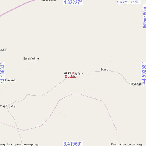
Xuddur GPS coordinates[2]
4° 7' 16.644" North, 43° 53' 22.02" East
| Map corner | latitude | longitude |
|---|---|---|
| Upper-left | 4.82227°, | 43.18633° |
| Center: | 4.12129°, | 43.88945° |
| Lower-right: | 3.41969°, | 44.59258° |
| Map W x H: | 156×156 km | = 96.9×96.9mi |
| max Lat: | 11.96611° ⇑52.8% North |
| Xuddur: | 4.12129° |
| min Lat: | ⇓47.2% South -1.21917° |
| min Long | Xuddur | max Long |
| 41.83725° | 43.88945° | 51.0773° |
| W 26.4%⇐ | ⇒73.6% E |
Elevation
Elevation of Xuddur is 493 m = 1617 ft, and this is 203.1 m = 666 ft above average elevation for this country.
| Max E: |
1786 m = 5860 ft | 15.1% |
| Xuddur | 493 m 1617 ft | |
| Avg. | 289.9 m = 951 ft | |
Min E: |
-2 m = -7 ft | 84.9% |
See also: Somalia elevation on elevation.city.
Geographical zone
Xuddur is located in North Torrid zone (between Equator and Tropic of Cancer). Distance of Equator is 458.2 km =284.7 mi to South.| Distance of | km | miles | from Xuddur |
|---|---|---|---|
| North Pole | 9548.8 | 5933.3 | to North |
| Arctic Circle | 6942.9 | 4314.1 | to North |
| Tropic Cancer | 2147.7 | 1334.5 | to North |
| Equator | 458.2 | 284.7 | to South |


Nearby cities:
15 places around Xuddur: (largest is in red/bold)
• Afgooye
259.5 km =161.2 mi,  148°
148°
• Baardheere
266.6 km =165.7 mi,  222°
222°
• Baidoa
115.1 km =71.5 mi,  193°
193°
• Beledweyne
160.9 km =100 mi,  64°
64°
• Buulobarde
188.5 km =117.1 mi,  99°
99°
• Buurhakaba
148.1 km =92 mi,  171°
171°
• Garbahaarrey
205 km =127.4 mi,  244°
244°
• Jalalaqsi
207 km =128.6 mi,  113°
113°
• Jawhar
232.8 km =144.7 mi,  129°
129°
• Luuq
153.4 km =95.3 mi,  256°
256°
• Mahaddayweyne
222.8 km =138.4 mi,  124°
124°
• Tayeeglow
69.9 km =43.4 mi, 99°
• Waajid
79.3 km =49.3 mi, 244°
• Wanlaweyn
200.9 km =124.8 mi, 146°
• Yeed
106.2 km =66 mi,  296°
296°
Sources, notices
• [Note1] Compared only with cities in Somalia existing in our database
• [Src1] Map data: © OpenStreetMap contributors (CC-BY-SA)
• [Src2] Other city data from geonames.org with taken over terms of usage.
• [Src3] Geographical zone / Annual Mean Temperature by Robert A. Rohde @ Wikipedia
