Mahaddayweyne geodata
Mahaddayweyne (Middle Shabele) is a populated place; located in Somalia in Africa/Mogadishu (GMT+3) time zone. With population of 8,273 people, there are 36 cities with bigger population in this country. Compared to other cities in Somalia, 69.8% of cities are located further ↑North; 58.5% of cities are located further ←West and 50.9% of cities have lower elevation than Mahaddayweyne. Note1


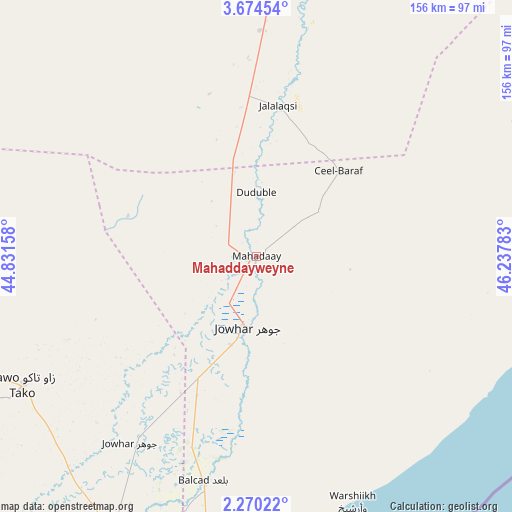
Mahaddayweyne GPS coordinates[2]
2° 58' 21.36" North, 45° 32' 4.92" East
| Map corner | latitude | longitude |
|---|---|---|
| Upper-left | 3.67454°, | 44.83158° |
| Center: | 2.9726°, | 45.5347° |
| Lower-right: | 2.27022°, | 46.23783° |
| Map W x H: | 156.1×156.1 km | = 97×97mi |
| max Lat: | 11.96611° ⇑69.8% North |
| Mahaddayweyne: | 2.9726° |
| min Lat: | ⇓30.2% South -1.21917° |
| min Long | Mahaddayweyne | max Long |
| 41.83725° | 45.5347° | 51.0773° |
| W 58.5%⇐ | ⇒41.5% E |
Elevation
Elevation of Mahaddayweyne is 114 m = 374 ft, and this is 175.9 m = 577 ft below average elevation for this country.
| Max E: |
1786 m = 5860 ft | 49.1% |
| Avg. | 289.9 m = 951 ft | |
| Mahaddayweyne | 114 m = 374 ft | |
Min E: |
-2 m = -7 ft | 50.9% |
See also: Somalia elevation on elevation.city.
Geographical zone
Mahaddayweyne is located in North Torrid zone (between Equator and Tropic of Cancer). Distance of Equator is 330.5 km =205.4 mi to South.| Distance of | km | miles | from Mahaddayweyne |
|---|---|---|---|
| North Pole | 9676.5 | 6012.7 | to North |
| Arctic Circle | 7070.7 | 4393.5 | to North |
| Tropic Cancer | 2275.4 | 1413.9 | to North |
| Equator | 330.5 | 205.4 | to South |


Nearby cities:
15 places around Mahaddayweyne: (largest is in red/bold)
• Afgooye
103.5 km =64.3 mi,  206°
206°
• Baidoa
209.9 km =130.4 mi,  274°
274°
• Beledweyne
199.5 km =124 mi,  349°
349°
• Buulobarde
98 km =60.9 mi,  2°
2°
• Buurhakaba
162.9 km =101.2 mi,  263°
263°
• Cadale
90.6 km =56.3 mi,  105°
105°
• Ceeldheer
207 km =128.6 mi,  61°
61°
• Jalalaqsi
45.5 km =28.3 mi,  9°
9°
• Jawhar
21.7 km =13.5 mi,  190°
190°
• Marka
163.4 km =101.5 mi, 211°
• Mogadishu
106.2 km =66 mi, 191°
• Qoryooley
172.7 km =107.3 mi,  220°
220°
• Tayeeglow
162.6 km =101 mi,  315°
315°
• Wanlaweyn
81.3 km =50.5 mi,  241°
241°
• Xuddur
222.8 km =138.4 mi,  304°
304°
Sources, notices
• [Note1] Compared only with cities in Somalia existing in our database
• [Src1] Map data: © OpenStreetMap contributors (CC-BY-SA)
• [Src2] Other city data from geonames.org with taken over terms of usage.
• [Src3] Geographical zone / Annual Mean Temperature by Robert A. Rohde @ Wikipedia
