Beledweyne geodata
Beledweyne (Hiiraan) is a seat of a first-order administrative division; located in Somalia in Africa/Mogadishu (GMT+3) time zone. With population of 55,410 people, there are 13 cities with bigger population in this country. Compared to other cities in Somalia, 54.7% of cities are located further ↓South; 50.9% of cities are located further →East and 60.4% of cities have lower elevation than Beledweyne. Note1


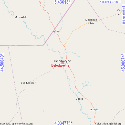
Beledweyne GPS coordinates[2]
4° 44' 8.988" North, 45° 12' 12.996" East
| Map corner | latitude | longitude |
|---|---|---|
| Upper-left | 5.43618°, | 44.50049° |
| Center: | 4.73583°, | 45.20361° |
| Lower-right: | 4.03477°, | 45.90674° |
| Map W x H: | 155.8×155.8 km | = 96.8×96.8mi |
| max Lat: | 11.96611° ⇑45.3% North |
| Beledweyne: | 4.73583° |
| min Lat: | ⇓54.7% South -1.21917° |
| min Long | Beledweyne | max Long |
| 41.83725° | 45.20361° | 51.0773° |
| W 49.1%⇐ | ⇒50.9% E |
Elevation
Elevation of Beledweyne is 182 m = 597 ft, and this is 107.9 m = 354 ft below average elevation for this country.
| Max E: |
1786 m = 5860 ft | 39.6% |
| Avg. | 289.9 m = 951 ft | |
| Beledweyne | 182 m = 597 ft | |
Min E: |
-2 m = -7 ft | 60.4% |
See also: Beledweyne elevation on elevation.city.
Geographical zone
Beledweyne is located in North Torrid zone (between Equator and Tropic of Cancer). Distance of Equator is 526.6 km =327.2 mi to South.| Distance of | km | miles | from Beledweyne |
|---|---|---|---|
| North Pole | 9480.5 | 5890.9 | to North |
| Arctic Circle | 6874.6 | 4271.7 | to North |
| Tropic Cancer | 2079.3 | 1292 | to North |
| Equator | 526.6 | 327.2 | to South |


Nearby cities:
15 places around Beledweyne: (largest is in red/bold)
• Adado
221.5 km =137.6 mi,  45°
45°
• Baidoa
249.5 km =155 mi,  223°
223°
• Buulobarde
106.1 km =65.9 mi,  157°
157°
• Buurhakaba
248.6 km =154.5 mi,  210°
210°
• Ceelbuur
156.8 km =97.4 mi,  92°
92°
• Ceeldheer
240.4 km =149.4 mi,  114°
114°
• Dhuusamarreeb
158.4 km =98.4 mi,  55°
55°
• Jalalaqsi
157.4 km =97.8 mi, 163°
• Jawhar
219.9 km =136.6 mi,  171°
171°
• Mahaddayweyne
199.5 km =124 mi, 169°
• Tayeeglow
110.7 km =68.8 mi, 223°
• Waajid
240.2 km =149.3 mi,  244°
244°
• Wanlaweyn
237.9 km =147.8 mi,  188°
188°
• Xuddur
160.9 km =100 mi, 244°
• Yeed
241.4 km =150 mi,  265°
265°
Sources, notices
• [Note1] Compared only with cities in Somalia existing in our database
• [Src1] Map data: © OpenStreetMap contributors (CC-BY-SA)
• [Src2] Other city data from geonames.org with taken over terms of usage.
• [Src3] Geographical zone / Annual Mean Temperature by Robert A. Rohde @ Wikipedia
