Tayeeglow geodata
Tayeeglow (Bakool) is a populated place; located in Somalia in Africa/Mogadishu (GMT+3) time zone. With population of 2,119 people, there are 48 cities with bigger population in this country. Compared to other cities in Somalia, 54.7% of cities are located further ↑North; 64.2% of cities are located further →East and 79.2% of cities have lower elevation than Tayeeglow. Note1


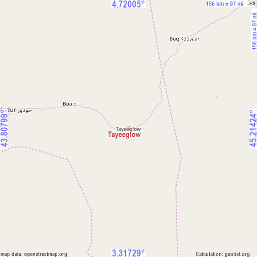
Tayeeglow GPS coordinates[2]
4° 1' 8.292" North, 44° 30' 39.996" East
| Map corner | latitude | longitude |
|---|---|---|
| Upper-left | 4.72005°, | 43.80799° |
| Center: | 4.01897°, | 44.51111° |
| Lower-right: | 3.31729°, | 45.21424° |
| Map W x H: | 156×156 km | = 96.9×96.9mi |
| max Lat: | 11.96611° ⇑54.7% North |
| Tayeeglow: | 4.01897° |
| min Lat: | ⇓45.3% South -1.21917° |
| min Long | Tayeeglow | max Long |
| 41.83725° | 44.51111° | 51.0773° |
| W 35.8%⇐ | ⇒64.2% E |
Elevation
Elevation of Tayeeglow is 410 m = 1345 ft, and this is 120.1 m = 394 ft above average elevation for this country.
| Max E: |
1786 m = 5860 ft | 20.8% |
| Tayeeglow | 410 m 1345 ft | |
| Avg. | 289.9 m = 951 ft | |
Min E: |
-2 m = -7 ft | 79.2% |
See also: Somalia elevation on elevation.city.
Geographical zone
Tayeeglow is located in North Torrid zone (between Equator and Tropic of Cancer). Distance of Equator is 446.9 km =277.7 mi to South.| Distance of | km | miles | from Tayeeglow |
|---|---|---|---|
| North Pole | 9560.2 | 5940.4 | to North |
| Arctic Circle | 6954.3 | 4321.2 | to North |
| Tropic Cancer | 2159.1 | 1341.6 | to North |
| Equator | 446.9 | 277.7 | to South |


Nearby cities:
15 places around Tayeeglow: (largest is in red/bold)
• Afgooye
219.8 km =136.6 mi,  162°
162°
• Baidoa
138.8 km =86.2 mi,  223°
223°
• Beledweyne
110.7 km =68.8 mi,  43°
43°
• Buulobarde
118.6 km =73.7 mi,  98°
98°
• Buurhakaba
143.5 km =89.2 mi,  199°
199°
• Cadale
244.9 km =152.2 mi,  124°
124°
• Jalalaqsi
140.3 km =87.2 mi, 120°
• Jawhar
176.1 km =109.4 mi,  141°
141°
• Luuq
219.5 km =136.4 mi,  263°
263°
• Mahaddayweyne
162.6 km =101 mi, 135°
• Mogadishu
239 km =148.5 mi, 157°
• Waajid
142.2 km =88.4 mi, 260°
• Wanlaweyn
161.4 km =100.3 mi, 164°
• Xuddur
69.9 km =43.4 mi,  279°
279°
• Yeed
174.2 km =108.2 mi,  289°
289°
Sources, notices
• [Note1] Compared only with cities in Somalia existing in our database
• [Src1] Map data: © OpenStreetMap contributors (CC-BY-SA)
• [Src2] Other city data from geonames.org with taken over terms of usage.
• [Src3] Geographical zone / Annual Mean Temperature by Robert A. Rohde @ Wikipedia
