Jawhar geodata
Jawhar (Middle Shabele) is a seat of a first-order administrative division; located in Somalia in Africa/Mogadishu (GMT+3) time zone. With population of 47,086 people, there are 15 cities with bigger population in this country. Compared to other cities in Somalia, 73.6% of cities are located further ↑North; 54.7% of cities are located further ←West and 50.9% of cities have higher elevation than Jawhar. Note1


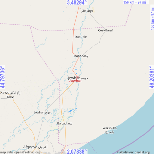
Jawhar GPS coordinates[2]
2° 46' 51.132" North, 45° 30' 1.728" East
| Map corner | latitude | longitude |
|---|---|---|
| Upper-left | 3.48294°, | 44.79736° |
| Center: | 2.78087°, | 45.50048° |
| Lower-right: | 2.07838°, | 46.20361° |
| Map W x H: | 156.2×156.2 km | = 97.1×97.1mi |
| max Lat: | 11.96611° ⇑73.6% North |
| Jawhar: | 2.78087° |
| min Lat: | ⇓26.4% South -1.21917° |
| min Long | Jawhar | max Long |
| 41.83725° | 45.50048° | 51.0773° |
| W 54.7%⇐ | ⇒45.3% E |
Elevation
Elevation of Jawhar is 108 m = 354 ft, and this is 181.9 m = 597 ft below average elevation for this country.
| Max E: |
1786 m = 5860 ft | 50.9% |
| Avg. | 289.9 m = 951 ft | |
| Jawhar | 108 m = 354 ft | |
Min E: |
-2 m = -7 ft | 49.1% |
See also: Jawhar elevation on elevation.city.
Geographical zone
Jawhar is located in North Torrid zone (between Equator and Tropic of Cancer). Distance of Equator is 309.2 km =192.1 mi to South.| Distance of | km | miles | from Jawhar |
|---|---|---|---|
| North Pole | 9697.9 | 6026 | to North |
| Arctic Circle | 7092 | 4406.8 | to North |
| Tropic Cancer | 2296.7 | 1427.1 | to North |
| Equator | 309.2 | 192.1 | to South |


Nearby cities:
15 places around Jawhar: (largest is in red/bold)
• Afgooye
83 km =51.6 mi,  210°
210°
• Baidoa
208.8 km =129.7 mi,  280°
280°
• Beledweyne
219.9 km =136.6 mi,  351°
351°
• Buulobarde
119.5 km =74.3 mi,  3°
3°
• Buurhakaba
158 km =98.2 mi,  270°
270°
• Cadale
91.3 km =56.7 mi,  91°
91°
• Ceeldheer
221.1 km =137.4 mi,  57°
57°
• Jalalaqsi
67.1 km =41.7 mi,  9°
9°
• Mahaddayweyne
21.7 km =13.5 mi, 10°
• Marka
143.4 km =89.1 mi, 214°
• Mogadishu
84.5 km =52.5 mi,  191°
191°
• Qoryooley
154.3 km =95.9 mi,  224°
224°
• Tayeeglow
176.1 km =109.4 mi,  321°
321°
• Wanlaweyn
69.8 km =43.4 mi,  255°
255°
• Xuddur
232.8 km =144.7 mi,  309°
309°
Sources, notices
• [Note1] Compared only with cities in Somalia existing in our database
• [Src1] Map data: © OpenStreetMap contributors (CC-BY-SA)
• [Src2] Other city data from geonames.org with taken over terms of usage.
• [Src3] Geographical zone / Annual Mean Temperature by Robert A. Rohde @ Wikipedia
