Wanlaweyn geodata
Wanlaweyn (Lower Shabeelle) is a populated place; located in Somalia in Africa/Mogadishu (GMT+3) time zone. With population of 22,022 people, there are 22 cities with bigger population in this country. Compared to other cities in Somalia, 77.4% of cities are located further ↑North; 58.5% of cities are located further →East and 54.7% of cities have higher elevation than Wanlaweyn. Note1


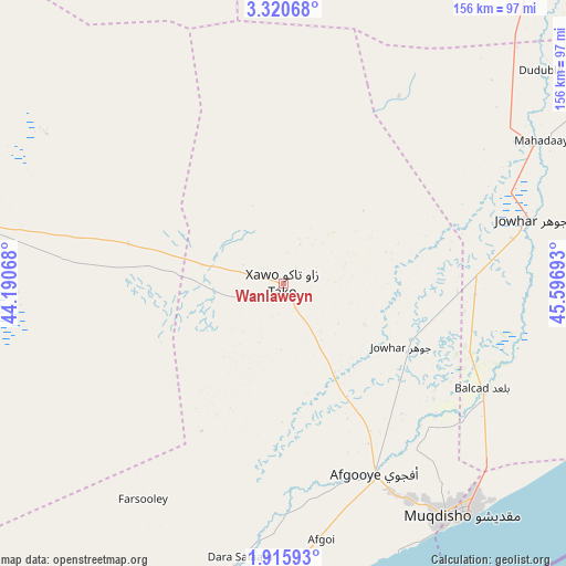
Wanlaweyn GPS coordinates[2]
2° 37' 6.6" North, 44° 53' 37.68" East
| Map corner | latitude | longitude |
|---|---|---|
| Upper-left | 3.32068°, | 44.19068° |
| Center: | 2.6185°, | 44.8938° |
| Lower-right: | 1.91593°, | 45.59693° |
| Map W x H: | 156.2×156.2 km | = 97.1×97.1mi |
| max Lat: | 11.96611° ⇑77.4% North |
| Wanlaweyn: | 2.6185° |
| min Lat: | ⇓22.6% South -1.21917° |
| min Long | Wanlaweyn | max Long |
| 41.83725° | 44.8938° | 51.0773° |
| W 41.5%⇐ | ⇒58.5% E |
Elevation
Elevation of Wanlaweyn is 93 m = 305 ft, and this is 196.9 m = 646 ft below average elevation for this country.
| Max E: |
1786 m = 5860 ft | 54.7% |
| Avg. | 289.9 m = 951 ft | |
| Wanlaweyn | 93 m = 305 ft | |
Min E: |
-2 m = -7 ft | 45.3% |
See also: Somalia elevation on elevation.city.
Geographical zone
Wanlaweyn is located in North Torrid zone (between Equator and Tropic of Cancer). Distance of Equator is 291.1 km =180.9 mi to South.| Distance of | km | miles | from Wanlaweyn |
|---|---|---|---|
| North Pole | 9715.9 | 6037.2 | to North |
| Arctic Circle | 7110 | 4417.9 | to North |
| Tropic Cancer | 2314.8 | 1438.3 | to North |
| Equator | 291.1 | 180.9 | to South |


Nearby cities:
15 places around Wanlaweyn: (largest is in red/bold)
• Afgooye
59.1 km =36.7 mi,  154°
154°
• Baidoa
148.7 km =92.4 mi,  291°
291°
• Beledweyne
237.9 km =147.8 mi,  8°
8°
• Buulobarde
156.4 km =97.2 mi,  28°
28°
• Buurhakaba
92.9 km =57.7 mi,  282°
282°
• Cadale
159.4 km =99 mi,  84°
84°
• Jalalaqsi
115.1 km =71.5 mi,  42°
42°
• Jawhar
69.8 km =43.4 mi, 75°
• Mahaddayweyne
81.3 km =50.5 mi,  61°
61°
• Marka
101.3 km =62.9 mi,  187°
187°
• Mogadishu
81.7 km =50.8 mi,  142°
142°
• Qoryooley
100.8 km =62.6 mi,  203°
203°
• Tayeeglow
161.4 km =100.3 mi,  344°
344°
• Waajid
225.8 km =140.3 mi,  305°
305°
• Xuddur
200.9 km =124.8 mi,  326°
326°
Sources, notices
• [Note1] Compared only with cities in Somalia existing in our database
• [Src1] Map data: © OpenStreetMap contributors (CC-BY-SA)
• [Src2] Other city data from geonames.org with taken over terms of usage.
• [Src3] Geographical zone / Annual Mean Temperature by Robert A. Rohde @ Wikipedia
