Baidoa geodata
Baidoa (Bay) is a seat of a first-order administrative division; located in Somalia in Africa/Mogadishu (GMT+3) time zone. With population of 129,839 people, there are 6 cities with bigger population in this country. Compared to other cities in Somalia, 67.9% of cities are located further ↑North; 75.5% of cities are located further →East and 81.1% of cities have lower elevation than Baidoa. Note1


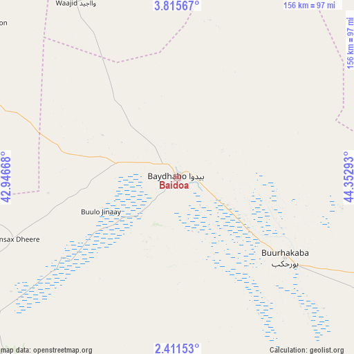
Baidoa GPS coordinates[2]
3° 6' 49.788" North, 43° 38' 59.28" East
| Map corner | latitude | longitude |
|---|---|---|
| Upper-left | 3.81567°, | 42.94668° |
| Center: | 3.11383°, | 43.6498° |
| Lower-right: | 2.41153°, | 44.35293° |
| Map W x H: | 156.1×156.1 km | = 97×97mi |
| max Lat: | 11.96611° ⇑67.9% North |
| Baidoa: | 3.11383° |
| min Lat: | ⇓32.1% South -1.21917° |
| min Long | Baidoa | max Long |
| 41.83725° | 43.6498° | 51.0773° |
| W 24.5%⇐ | ⇒75.5% E |
Elevation
Elevation of Baidoa is 441 m = 1447 ft, and this is 151.1 m = 496 ft above average elevation for this country.
| Max E: |
1786 m = 5860 ft | 18.9% |
| Baidoa | 441 m 1447 ft | |
| Avg. | 289.9 m = 951 ft | |
Min E: |
-2 m = -7 ft | 81.1% |
See also: Baidoa elevation on elevation.city.
Geographical zone
Baidoa is located in North Torrid zone (between Equator and Tropic of Cancer). Distance of Equator is 346.2 km =215.1 mi to South.| Distance of | km | miles | from Baidoa |
|---|---|---|---|
| North Pole | 9660.8 | 6002.9 | to North |
| Arctic Circle | 7054.9 | 4383.7 | to North |
| Tropic Cancer | 2259.7 | 1404.1 | to North |
| Equator | 346.2 | 215.1 | to South |


Nearby cities:
15 places around Baidoa: (largest is in red/bold)
• Afgooye
196.2 km =121.9 mi,  123°
123°
• Baardheere
174.9 km =108.7 mi,  240°
240°
• Buurhakaba
58.8 km =36.5 mi,  126°
126°
• Garbahaarrey
160.4 km =99.7 mi,  278°
278°
• Jawhar
208.8 km =129.7 mi,  100°
100°
• Luuq
144.7 km =89.9 mi,  301°
301°
• Mahaddayweyne
209.9 km =130.4 mi,  94°
94°
• Marka
199.2 km =123.8 mi,  141°
141°
• Qoryooley
176.9 km =109.9 mi,  146°
146°
• Saacow
212.9 km =132.3 mi,  219°
219°
• Tayeeglow
138.8 km =86.2 mi,  43°
43°
• Waajid
89.4 km =55.6 mi,  329°
329°
• Wanlaweyn
148.7 km =92.4 mi,  111°
111°
• Xuddur
115.1 km =71.5 mi,  13°
13°
• Yeed
173.7 km =107.9 mi,  336°
336°
Sources, notices
• [Note1] Compared only with cities in Somalia existing in our database
• [Src1] Map data: © OpenStreetMap contributors (CC-BY-SA)
• [Src2] Other city data from geonames.org with taken over terms of usage.
• [Src3] Geographical zone / Annual Mean Temperature by Robert A. Rohde @ Wikipedia
