Buurhakaba geodata
Buurhakaba (Bay) is a seat of a second-order administrative division; located in Somalia in Africa/Mogadishu (GMT+3) time zone. With population of 27,792 people, there are 20 cities with bigger population in this country. Compared to other cities in Somalia, 71.7% of cities are located further ↑North; 66% of cities are located further →East and 67.9% of cities have lower elevation than Buurhakaba. Note1


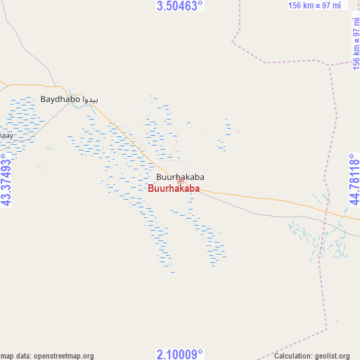
Buurhakaba GPS coordinates[2]
2° 48' 9.252" North, 44° 4' 40.98" East
| Map corner | latitude | longitude |
|---|---|---|
| Upper-left | 3.50463°, | 43.37493° |
| Center: | 2.80257°, | 44.07805° |
| Lower-right: | 2.10009°, | 44.78118° |
| Map W x H: | 156.2×156.2 km | = 97.1×97.1mi |
| max Lat: | 11.96611° ⇑71.7% North |
| Buurhakaba: | 2.80257° |
| min Lat: | ⇓28.3% South -1.21917° |
| min Long | Buurhakaba | max Long |
| 41.83725° | 44.07805° | 51.0773° |
| W 34%⇐ | ⇒66% E |
Elevation
Elevation of Buurhakaba is 277 m = 909 ft, and this is 12.9 m = 42 ft below average elevation for this country.
| Max E: |
1786 m = 5860 ft | 32.1% |
| Avg. | 289.9 m = 951 ft | |
| Buurhakaba | 277 m = 909 ft | |
Min E: |
-2 m = -7 ft | 67.9% |
See also: Somalia elevation on elevation.city.
Geographical zone
Buurhakaba is located in North Torrid zone (between Equator and Tropic of Cancer). Distance of Equator is 311.6 km =193.6 mi to South.| Distance of | km | miles | from Buurhakaba |
|---|---|---|---|
| North Pole | 9695.4 | 6024.4 | to North |
| Arctic Circle | 7089.6 | 4405.3 | to North |
| Tropic Cancer | 2294.3 | 1425.6 | to North |
| Equator | 311.6 | 193.6 | to South |


Nearby cities:
15 places around Buurhakaba: (largest is in red/bold)
• Afgooye
137.4 km =85.4 mi,  122°
122°
• Baardheere
206.5 km =128.3 mi,  255°
255°
• Baidoa
58.8 km =36.5 mi,  306°
306°
• Buulobarde
202.5 km =125.8 mi,  54°
54°
• Jalalaqsi
180.6 km =112.2 mi,  69°
69°
• Jawhar
158 km =98.2 mi,  90°
90°
• Luuq
203.4 km =126.4 mi,  303°
303°
• Mahaddayweyne
162.9 km =101.2 mi,  83°
83°
• Marka
143.3 km =89 mi,  147°
147°
• Mogadishu
164.4 km =102.2 mi, 121°
• Qoryooley
123.5 km =76.7 mi,  156°
156°
• Tayeeglow
143.5 km =89.2 mi,  19°
19°
• Waajid
145.1 km =90.2 mi,  320°
320°
• Wanlaweyn
92.9 km =57.7 mi,  102°
102°
• Xuddur
148.1 km =92 mi,  351°
351°
Sources, notices
• [Note1] Compared only with cities in Somalia existing in our database
• [Src1] Map data: © OpenStreetMap contributors (CC-BY-SA)
• [Src2] Other city data from geonames.org with taken over terms of usage.
• [Src3] Geographical zone / Annual Mean Temperature by Robert A. Rohde @ Wikipedia
