Waajid geodata
Waajid (Bakool) is a populated place; located in Somalia in Africa/Mogadishu (GMT+3) time zone. With population of 6,666 people, there are 40 cities with bigger population in this country. Compared to other cities in Somalia, 60.4% of cities are located further ↑North; 79.2% of cities are located further →East and 77.4% of cities have lower elevation than Waajid. Note1


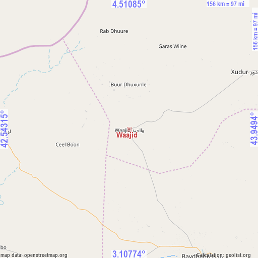
Waajid GPS coordinates[2]
3° 48' 34.488" North, 43° 14' 46.572" East
| Map corner | latitude | longitude |
|---|---|---|
| Upper-left | 4.51085°, | 42.54315° |
| Center: | 3.80958°, | 43.24627° |
| Lower-right: | 3.10774°, | 43.9494° |
| Map W x H: | 156×156 km | = 96.9×96.9mi |
| max Lat: | 11.96611° ⇑60.4% North |
| Waajid: | 3.80958° |
| min Lat: | ⇓39.6% South -1.21917° |
| min Long | Waajid | max Long |
| 41.83725° | 43.24627° | 51.0773° |
| W 20.8%⇐ | ⇒79.2% E |
Elevation
Elevation of Waajid is 381 m = 1250 ft, and this is 91.1 m = 299 ft above average elevation for this country.
| Max E: |
1786 m = 5860 ft | 22.6% |
| Waajid | 381 m 1250 ft | |
| Avg. | 289.9 m = 951 ft | |
Min E: |
-2 m = -7 ft | 77.4% |
See also: Somalia elevation on elevation.city.
Geographical zone
Waajid is located in North Torrid zone (between Equator and Tropic of Cancer). Distance of Equator is 423.6 km =263.2 mi to South.| Distance of | km | miles | from Waajid |
|---|---|---|---|
| North Pole | 9583.5 | 5954.9 | to North |
| Arctic Circle | 6977.6 | 4335.7 | to North |
| Tropic Cancer | 2182.3 | 1356 | to North |
| Equator | 423.6 | 263.2 | to South |


Nearby cities:
15 places around Waajid: (largest is in red/bold)
• Baardheere
195.3 km =121.4 mi,  213°
213°
• Baidoa
89.4 km =55.6 mi,  149°
149°
• Beledweyne
240.2 km =149.3 mi,  64°
64°
• Buulobarde
257.6 km =160.1 mi,  88°
88°
• Buurhakaba
145.1 km =90.2 mi,  140°
140°
• Garbahaarrey
125.7 km =78.1 mi,  244°
244°
• Jalalaqsi
265.6 km =165 mi,  100°
100°
• Luuq
77.9 km =48.4 mi,  269°
269°
• Mahaddayweyne
270.5 km =168.1 mi,  110°
110°
• Qoryooley
266.2 km =165.4 mi, 147°
• Saacow
258.5 km =160.6 mi,  200°
200°
• Tayeeglow
142.2 km =88.4 mi,  80°
80°
• Wanlaweyn
225.8 km =140.3 mi,  125°
125°
• Xuddur
79.3 km =49.3 mi, 64°
• Yeed
85.6 km =53.2 mi,  343°
343°
Sources, notices
• [Note1] Compared only with cities in Somalia existing in our database
• [Src1] Map data: © OpenStreetMap contributors (CC-BY-SA)
• [Src2] Other city data from geonames.org with taken over terms of usage.
• [Src3] Geographical zone / Annual Mean Temperature by Robert A. Rohde @ Wikipedia
