Béré geodata
Béré (Tandjilé) is a populated place; located in Chad in Africa/Ndjamena (GMT+1) time zone. With population of 14,666 people, there are 25 cities with bigger population in this country. Compared to other cities in Chad, 78.7% of cities are located further ↑North; 68.1% of cities are located further →East and 61.7% of cities have higher elevation than Béré. Note1


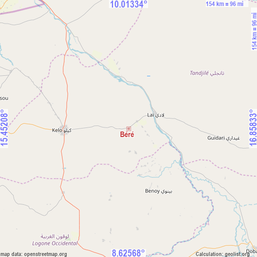
Béré GPS coordinates[2]
9° 19' 12.72" North, 16° 9' 18.72" East
| Map corner | latitude | longitude |
|---|---|---|
| Upper-left | 10.01334°, | 15.45208° |
| Center: | 9.3202°, | 16.1552° |
| Lower-right: | 8.62568°, | 16.85833° |
| Map W x H: | 154.3×154.3 km | = 95.9×95.9mi |
| max Lat: | 21.8375° ⇑78.7% North |
| Béré: | 9.3202° |
| min Lat: | ⇓21.3% South 8.26681° |
| min Long | Béré | max Long |
| 14.1539° | 16.1552° | 22.84308° |
| W 31.9%⇐ | ⇒68.1% E |
Elevation
Elevation of Béré is 361 m = 1184 ft, and this is 76.3 m = 250 ft below average elevation for this country.
| Max E: |
1046 m = 3432 ft | 61.7% |
| Avg. | 437.3 m = 1435 ft | |
| Béré | 361 m = 1184 ft | |
Min E: |
242 m = 794 ft | 38.3% |
See also: Chad elevation on elevation.city.
Geographical zone
Béré is located in North Torrid zone (between Equator and Tropic of Cancer). Distance of Equator is 1036.3 km =643.9 mi to South.| Distance of | km | miles | from Béré |
|---|---|---|---|
| North Pole | 8970.8 | 5574.2 | to North |
| Arctic Circle | 6364.9 | 3955 | to North |
| Tropic Cancer | 1569.6 | 975.3 | to North |
| Equator | 1036.3 | 643.9 | to South |


Nearby cities:
15 places around Béré: (largest is in red/bold)
• Benoy
41.6 km =25.8 mi,  154°
154°
• Beïnamar
111.6 km =69.3 mi,  229°
229°
• Bongor
137 km =85.1 mi,  321°
321°
• Bousso
143.1 km =88.9 mi,  25°
25°
• Béboto
145.4 km =90.3 mi,  143°
143°
• Bébédja
84.6 km =52.6 mi, 147°
• Doba
106.7 km =66.3 mi,  134°
134°
• Goundi
132.9 km =82.6 mi,  87°
87°
• Gounou Gaya
78.4 km =48.7 mi,  296°
296°
• Guelendeng
189.6 km =117.8 mi,  339°
339°
• Kelo
38.3 km =23.8 mi,  268°
268°
• Koumra
160.1 km =99.5 mi,  106°
106°
• Laï
18.1 km =11.2 mi,  61°
61°
• Moundou
84.2 km =52.3 mi,  185°
185°
• Pala
137.3 km =85.3 mi, 272°
Sources, notices
• [Note1] Compared only with cities in Chad existing in our database
• [Src1] Map data: © OpenStreetMap contributors (CC-BY-SA)
• [Src2] Other city data from geonames.org with taken over terms of usage.
• [Src3] Geographical zone / Annual Mean Temperature by Robert A. Rohde @ Wikipedia
