Moundou geodata
Moundou (Logone Occidental) is a seat of a first-order administrative division; located in Chad in Africa/Ndjamena (GMT+1) time zone. With population of 135,167 people, there is 1 city with bigger population in this country. Compared to other cities in Chad, 95.7% of cities are located further ↑North; 70.2% of cities are located further →East and 63.8% of cities have lower elevation than Moundou. Note1


Moundou GPS coordinates[2]
8° 34' 0.012" North, 16° 4' 59.988" East
| Map corner | latitude | longitude |
|---|---|---|
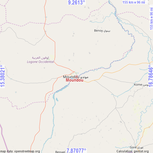
| Upper-left | 9.2613°, | 15.38021° |
| Center: | 8.56667°, | 16.08333° |
| Lower-right: | 7.87077°, | 16.78646° |
| Map W x H: | 154.6×154.6 km | = 96.1×96.1mi |
| max Lat: | 21.8375° ⇑95.7% North |
| Moundou: | 8.56667° |
| min Lat: | ⇓4.3% South 8.26681° |
| min Long | Moundou | max Long |
| 14.1539° | 16.08333° | 22.84308° |
| W 29.8%⇐ | ⇒70.2% E |
Elevation
Elevation of Moundou is 401 m = 1316 ft, and this is 36.3 m = 119 ft below average elevation for this country.
| Max E: |
1046 m = 3432 ft | 36.2% |
| Avg. | 437.3 m = 1435 ft | |
| Moundou | 401 m = 1316 ft | |
Min E: |
242 m = 794 ft | 63.8% |
See also: Moundou elevation on elevation.city.
Geographical zone
Moundou is located in North Torrid zone (between Equator and Tropic of Cancer). Distance of Equator is 952.5 km =591.9 mi to South.| Distance of | km | miles | from Moundou |
|---|---|---|---|
| North Pole | 9054.5 | 5626.2 | to North |
| Arctic Circle | 6448.6 | 4007 | to North |
| Tropic Cancer | 1653.4 | 1027.4 | to North |
| Equator | 952.5 | 591.9 | to South |


Nearby cities:
15 places around Moundou: (largest is in red/bold)
• Benoy
53.1 km =33 mi,  29°
29°
• Beïnamar
78 km =48.5 mi,  278°
278°
• Bongor
205.9 km =127.9 mi,  337°
337°
• Bousso
224.1 km =139.2 mi,  17°
17°
• Béboto
99.8 km =62 mi,  109°
109°
• Bébédja
54.4 km =33.8 mi,  77°
77°
• Béré
84.2 km =52.3 mi,  5°
5°
• Doba
84.8 km =52.7 mi, 83°
• Goundi
166.4 km =103.4 mi,  57°
57°
• Gounou Gaya
133.7 km =83.1 mi,  332°
332°
• Kelo
87.9 km =54.6 mi, 339°
• Koumra
166.1 km =103.2 mi, 76°
• Laï
95.4 km =59.3 mi, 14°
• Moïssala
186.8 km =116.1 mi,  97°
97°
• Pala
156.9 km =97.5 mi,  304°
304°
Sources, notices
• [Note1] Compared only with cities in Chad existing in our database
• [Src1] Map data: © OpenStreetMap contributors (CC-BY-SA)
• [Src2] Other city data from geonames.org with taken over terms of usage.
• [Src3] Geographical zone / Annual Mean Temperature by Robert A. Rohde @ Wikipedia
