Kelo geodata
Kelo (Tandjilé) is a populated place; located in Chad in Africa/Ndjamena (GMT+1) time zone. With population of 42,533 people, there are 4 cities with bigger population in this country. Compared to other cities in Chad, 80.9% of cities are located further ↑North; 74.5% of cities are located further →East and 55.3% of cities have higher elevation than Kelo. Note1


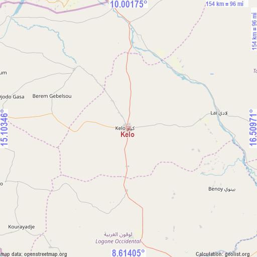
Kelo GPS coordinates[2]
9° 18' 30.924" North, 15° 48' 23.688" East
| Map corner | latitude | longitude |
|---|---|---|
| Upper-left | 10.00175°, | 15.10346° |
| Center: | 9.30859°, | 15.80658° |
| Lower-right: | 8.61405°, | 16.50971° |
| Map W x H: | 154.3×154.3 km | = 95.9×95.9mi |
| max Lat: | 21.8375° ⇑80.9% North |
| Kelo: | 9.30859° |
| min Lat: | ⇓19.1% South 8.26681° |
| min Long | Kelo | max Long |
| 14.1539° | 15.80658° | 22.84308° |
| W 25.5%⇐ | ⇒74.5% E |
Elevation
Elevation of Kelo is 375 m = 1230 ft, and this is 62.3 m = 204 ft below average elevation for this country.
| Max E: |
1046 m = 3432 ft | 55.3% |
| Avg. | 437.3 m = 1435 ft | |
| Kelo | 375 m = 1230 ft | |
Min E: |
242 m = 794 ft | 44.7% |
See also: Kelo elevation on elevation.city.
Geographical zone
Kelo is located in North Torrid zone (between Equator and Tropic of Cancer). Distance of Equator is 1035 km =643.1 mi to South.| Distance of | km | miles | from Kelo |
|---|---|---|---|
| North Pole | 8972 | 5574.9 | to North |
| Arctic Circle | 6366.2 | 3955.8 | to North |
| Tropic Cancer | 1570.9 | 976.1 | to North |
| Equator | 1035 | 643.1 | to South |


Nearby cities:
15 places around Kelo: (largest is in red/bold)
• Benoy
67 km =41.6 mi,  122°
122°
• Beïnamar
85 km =52.8 mi,  213°
213°
• Bongor
118.1 km =73.4 mi,  336°
336°
• Bousso
164 km =101.9 mi,  37°
37°
• Béboto
170 km =105.6 mi,  132°
132°
• Bébédja
109.1 km =67.8 mi, 130°
• Béré
38.3 km =23.8 mi,  88°
88°
• Doba
136 km =84.5 mi, 122°
• Goundi
171.2 km =106.4 mi, 87°
• Gounou Gaya
48 km =29.8 mi,  317°
317°
• Guelendeng
181.1 km =112.5 mi,  351°
351°
• Laï
55.1 km =34.2 mi,  79°
79°
• Mboursou Léré
188.2 km =116.9 mi,  285°
285°
• Moundou
87.9 km =54.6 mi,  159°
159°
• Pala
99.2 km =61.6 mi,  273°
273°
Sources, notices
• [Note1] Compared only with cities in Chad existing in our database
• [Src1] Map data: © OpenStreetMap contributors (CC-BY-SA)
• [Src2] Other city data from geonames.org with taken over terms of usage.
• [Src3] Geographical zone / Annual Mean Temperature by Robert A. Rohde @ Wikipedia
