Moïssala geodata
Moïssala (Mandoul) is a populated place; located in Chad in Africa/Ndjamena (GMT+1) time zone. With population of 11,264 people, there are 33 cities with bigger population in this country. Compared to other cities in Chad, 97.9% of cities are located further ↑North; 63.8% of cities are located further ←West and 51.1% of cities have lower elevation than Moïssala. Note1


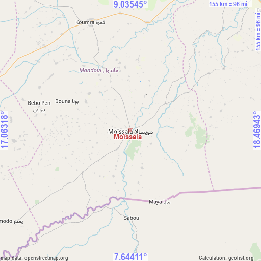
Moïssala GPS coordinates[2]
8° 20' 25.44" North, 17° 45' 58.68" East
| Map corner | latitude | longitude |
|---|---|---|
| Upper-left | 9.03545°, | 17.06318° |
| Center: | 8.3404°, | 17.7663° |
| Lower-right: | 7.64411°, | 18.46943° |
| Map W x H: | 154.7×154.7 km | = 96.1×96.1mi |
| max Lat: | 21.8375° ⇑97.9% North |
| Moïssala: | 8.3404° |
| min Lat: | ⇓2.1% South 8.26681° |
| min Long | Moïssala | max Long |
| 14.1539° | 17.7663° | 22.84308° |
| W 63.8%⇐ | ⇒36.2% E |
Elevation
Elevation of Moïssala is 385 m = 1263 ft, and this is 52.3 m = 172 ft below average elevation for this country.
| Max E: |
1046 m = 3432 ft | 48.9% |
| Avg. | 437.3 m = 1435 ft | |
| Moïssala | 385 m = 1263 ft | |
Min E: |
242 m = 794 ft | 51.1% |
See also: Chad elevation on elevation.city.
Geographical zone
Moïssala is located in North Torrid zone (between Equator and Tropic of Cancer). Distance of Equator is 927.4 km =576.3 mi to South.| Distance of | km | miles | from Moïssala |
|---|---|---|---|
| North Pole | 9079.7 | 5641.9 | to North |
| Arctic Circle | 6473.8 | 4022.6 | to North |
| Tropic Cancer | 1678.6 | 1043 | to North |
| Equator | 927.4 | 576.3 | to South |


Nearby cities:
15 places around Moïssala: (largest is in red/bold)
• Benoy
174.3 km =108.3 mi,  294°
294°
• Beïnamar
264.8 km =164.5 mi,  277°
277°
• Bousso
265.1 km =164.7 mi,  334°
334°
• Béboto
91.4 km =56.8 mi,  264°
264°
• Bébédja
137.2 km =85.3 mi, 285°
• Béré
207.9 km =129.2 mi,  301°
301°
• Doba
106.5 km =66.2 mi, 288°
• Goundi
121.9 km =75.7 mi,  338°
338°
• Gounou Gaya
286 km =177.7 mi, 300°
• Kelo
240.7 km =149.6 mi, 296°
• Koumra
67.8 km =42.1 mi, 339°
• Kyabé
179 km =111.2 mi,  46°
46°
• Laï
199.3 km =123.8 mi,  306°
306°
• Moundou
186.8 km =116.1 mi, 277°
• Sarh
112.7 km =70 mi,  37°
37°
Sources, notices
• [Note1] Compared only with cities in Chad existing in our database
• [Src1] Map data: © OpenStreetMap contributors (CC-BY-SA)
• [Src2] Other city data from geonames.org with taken over terms of usage.
• [Src3] Geographical zone / Annual Mean Temperature by Robert A. Rohde @ Wikipedia
