Doba geodata
Doba (Logone Oriental) is a seat of a first-order administrative division; located in Chad in Africa/Ndjamena (GMT+1) time zone. With population of 24,336 people, there are 10 cities with bigger population in this country. Compared to other cities in Chad, 93.6% of cities are located further ↑North; 53.2% of cities are located further →East and 51.1% of cities have higher elevation than Doba. Note1


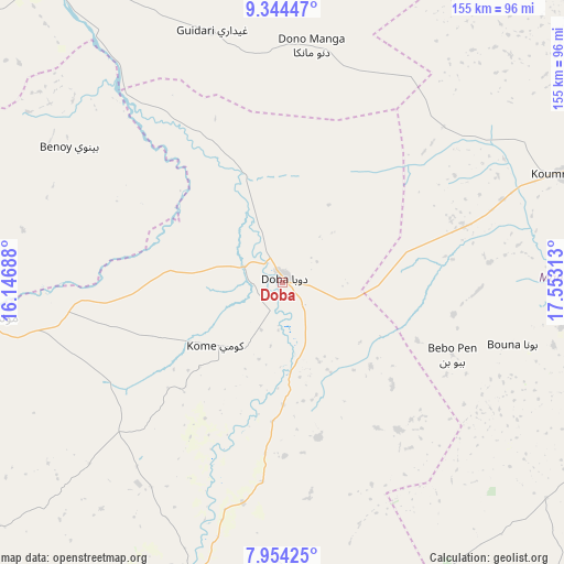
Doba GPS coordinates[2]
8° 39' 0" North, 16° 51' 0" East
| Map corner | latitude | longitude |
|---|---|---|
| Upper-left | 9.34447°, | 16.14688° |
| Center: | 8.65°, | 16.85° |
| Lower-right: | 7.95425°, | 17.55313° |
| Map W x H: | 154.6×154.6 km | = 96.1×96.1mi |
| max Lat: | 21.8375° ⇑93.6% North |
| Doba: | 8.65° |
| min Lat: | ⇓6.4% South 8.26681° |
| min Long | Doba | max Long |
| 14.1539° | 16.85° | 22.84308° |
| W 46.8%⇐ | ⇒53.2% E |
Elevation
Elevation of Doba is 379 m = 1243 ft, and this is 58.3 m = 191 ft below average elevation for this country.
| Max E: |
1046 m = 3432 ft | 51.1% |
| Avg. | 437.3 m = 1435 ft | |
| Doba | 379 m = 1243 ft | |
Min E: |
242 m = 794 ft | 48.9% |
See also: Chad elevation on elevation.city.
Geographical zone
Doba is located in North Torrid zone (between Equator and Tropic of Cancer). Distance of Equator is 961.8 km =597.6 mi to South.| Distance of | km | miles | from Doba |
|---|---|---|---|
| North Pole | 9045.3 | 5620.5 | to North |
| Arctic Circle | 6439.4 | 4001.3 | to North |
| Tropic Cancer | 1644.1 | 1021.6 | to North |
| Equator | 961.8 | 597.6 | to South |


Nearby cities:
15 places around Doba: (largest is in red/bold)
• Benoy
69 km =42.9 mi,  302°
302°
• Beïnamar
161.5 km =100.4 mi,  270°
270°
• Bousso
204.6 km =127.1 mi,  355°
355°
• Béboto
43.7 km =27.2 mi,  167°
167°
• Bébédja
31.4 km =19.5 mi,  275°
275°
• Béré
106.7 km =66.3 mi,  314°
314°
• Goundi
97.4 km =60.5 mi,  35°
35°
• Gounou Gaya
182.7 km =113.5 mi, 306°
• Kelo
136 km =84.5 mi, 302°
• Koumra
82.7 km =51.4 mi,  69°
69°
• Laï
102.7 km =63.8 mi,  324°
324°
• Moundou
84.8 km =52.7 mi,  263°
263°
• Moïssala
106.5 km =66.2 mi,  108°
108°
• Pala
227.9 km =141.6 mi,  290°
290°
• Sarh
178.1 km =110.7 mi, 72°
Sources, notices
• [Note1] Compared only with cities in Chad existing in our database
• [Src1] Map data: © OpenStreetMap contributors (CC-BY-SA)
• [Src2] Other city data from geonames.org with taken over terms of usage.
• [Src3] Geographical zone / Annual Mean Temperature by Robert A. Rohde @ Wikipedia
