Bébédja geodata
Bébédja (Logone Oriental) is a populated place; located in Chad in Africa/Ndjamena (GMT+1) time zone. With population of 12,671 people, there are 28 cities with bigger population in this country. Compared to other cities in Chad, 89.4% of cities are located further ↑North; 57.4% of cities are located further →East and 55.3% of cities have lower elevation than Bébédja. Note1


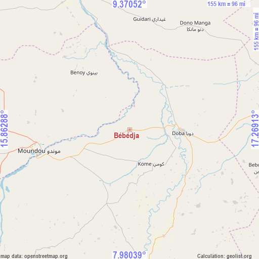
Bébédja GPS coordinates[2]
8° 40' 33.96" North, 16° 33' 57.6" East
| Map corner | latitude | longitude |
|---|---|---|
| Upper-left | 9.37052°, | 15.86288° |
| Center: | 8.6761°, | 16.566° |
| Lower-right: | 7.98039°, | 17.26913° |
| Map W x H: | 154.6×154.6 km | = 96.1×96.1mi |
| max Lat: | 21.8375° ⇑89.4% North |
| Bébédja: | 8.6761° |
| min Lat: | ⇓10.6% South 8.26681° |
| min Long | Bébédja | max Long |
| 14.1539° | 16.566° | 22.84308° |
| W 42.6%⇐ | ⇒57.4% E |
Elevation
Elevation of Bébédja is 395 m = 1296 ft, and this is 42.3 m = 139 ft below average elevation for this country.
| Max E: |
1046 m = 3432 ft | 44.7% |
| Avg. | 437.3 m = 1435 ft | |
| Bébédja | 395 m = 1296 ft | |
Min E: |
242 m = 794 ft | 55.3% |
See also: Chad elevation on elevation.city.
Geographical zone
Bébédja is located in North Torrid zone (between Equator and Tropic of Cancer). Distance of Equator is 964.7 km =599.4 mi to South.| Distance of | km | miles | from Bébédja |
|---|---|---|---|
| North Pole | 9042.4 | 5618.7 | to North |
| Arctic Circle | 6436.5 | 3999.5 | to North |
| Tropic Cancer | 1641.2 | 1019.8 | to North |
| Equator | 964.7 | 599.4 | to South |


Nearby cities:
15 places around Bébédja: (largest is in red/bold)
• Benoy
43.6 km =27.1 mi,  321°
321°
• Beïnamar
130.2 km =80.9 mi,  269°
269°
• Bousso
201.7 km =125.3 mi,  4°
4°
• Béboto
61.3 km =38.1 mi,  137°
137°
• Béré
84.6 km =52.6 mi,  327°
327°
• Doba
31.4 km =19.5 mi,  95°
95°
• Goundi
116.4 km =72.3 mi,  49°
49°
• Gounou Gaya
156.8 km =97.4 mi,  312°
312°
• Kelo
109.1 km =67.8 mi, 310°
• Koumra
111.7 km =69.4 mi,  76°
76°
• Laï
85.3 km =53 mi,  340°
340°
• Moundou
54.4 km =33.8 mi,  257°
257°
• Moïssala
137.2 km =85.3 mi,  105°
105°
• Pala
197.8 km =122.9 mi,  292°
292°
• Sarh
207.2 km =128.7 mi, 75°
Sources, notices
• [Note1] Compared only with cities in Chad existing in our database
• [Src1] Map data: © OpenStreetMap contributors (CC-BY-SA)
• [Src2] Other city data from geonames.org with taken over terms of usage.
• [Src3] Geographical zone / Annual Mean Temperature by Robert A. Rohde @ Wikipedia
