Béboto geodata
Béboto (Logone Oriental) is a populated place; located in Chad in Africa/Ndjamena (GMT+1) time zone. With population of 5,432 people, there are 39 cities with bigger population in this country. Compared to other cities in Chad, 100% of cities are located further ↑North; 51.1% of cities are located further →East and 72.3% of cities have lower elevation than Béboto. Note1


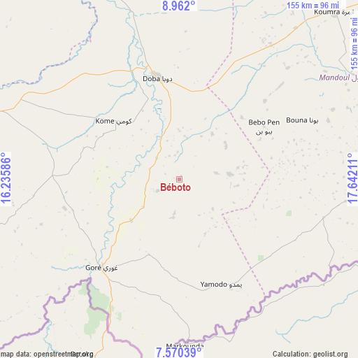
Béboto GPS coordinates[2]
8° 16' 0.516" North, 16° 56' 20.328" East
| Map corner | latitude | longitude |
|---|---|---|
| Upper-left | 8.962°, | 16.23586° |
| Center: | 8.26681°, | 16.93898° |
| Lower-right: | 7.57039°, | 17.64211° |
| Map W x H: | 154.7×154.7 km | = 96.1×96.1mi |
| max Lat: | 21.8375° ⇑100% North |
| Béboto: | 8.26681° |
| min Lat: | ⇓0% South 8.26681° |
| min Long | Béboto | max Long |
| 14.1539° | 16.93898° | 22.84308° |
| W 48.9%⇐ | ⇒51.1% E |
Elevation
Elevation of Béboto is 437 m = 1434 ft, and this is 0.30000000000001 m = 1 ft below average elevation for this country.
| Max E: |
1046 m = 3432 ft | 27.7% |
| Avg. | 437.3 m = 1435 ft | |
| Béboto | 437 m = 1434 ft | |
Min E: |
242 m = 794 ft | 72.3% |
See also: Chad elevation on elevation.city.
Geographical zone
Béboto is located in North Torrid zone (between Equator and Tropic of Cancer). Distance of Equator is 919.2 km =571.2 mi to South.| Distance of | km | miles | from Béboto |
|---|---|---|---|
| North Pole | 9087.9 | 5647 | to North |
| Arctic Circle | 6482 | 4027.7 | to North |
| Tropic Cancer | 1686.7 | 1048.1 | to North |
| Equator | 919.2 | 571.2 | to South |


Nearby cities:
15 places around Béboto: (largest is in red/bold)
• Benoy
104.8 km =65.1 mi,  319°
319°
• Beïnamar
177.1 km =110 mi,  284°
284°
• Bousso
247.9 km =154 mi,  354°
354°
• Bébédja
61.3 km =38.1 mi, 317°
• Béré
145.4 km =90.3 mi, 323°
• Doba
43.7 km =27.2 mi, 347°
• Goundi
130.6 km =81.2 mi,  21°
21°
• Gounou Gaya
217.9 km =135.4 mi,  314°
314°
• Kelo
170 km =105.6 mi, 312°
• Koumra
98.6 km =61.3 mi,  43°
43°
• Laï
143.9 km =89.4 mi,  330°
330°
• Moundou
99.8 km =62 mi,  289°
289°
• Moïssala
91.4 km =56.8 mi,  84°
84°
• Pala
254.7 km =158.3 mi,  298°
298°
• Sarh
187.1 km =116.3 mi,  58°
58°
Sources, notices
• [Note1] Compared only with cities in Chad existing in our database
• [Src1] Map data: © OpenStreetMap contributors (CC-BY-SA)
• [Src2] Other city data from geonames.org with taken over terms of usage.
• [Src3] Geographical zone / Annual Mean Temperature by Robert A. Rohde @ Wikipedia
