Laï geodata
Laï (Tandjilé) is a seat of a first-order administrative division; located in Chad in Africa/Ndjamena (GMT+1) time zone. With population of 19,382 people, there are 13 cities with bigger population in this country. Compared to other cities in Chad, 72.3% of cities are located further ↑North; 63.8% of cities are located further →East and 59.6% of cities have higher elevation than Laï. Note1


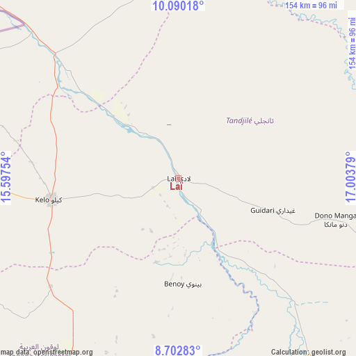
Laï GPS coordinates[2]
9° 23' 49.92" North, 16° 18' 2.376" East
| Map corner | latitude | longitude |
|---|---|---|
| Upper-left | 10.09018°, | 15.59754° |
| Center: | 9.3972°, | 16.30066° |
| Lower-right: | 8.70283°, | 17.00379° |
| Map W x H: | 154.3×154.3 km | = 95.9×95.9mi |
| max Lat: | 21.8375° ⇑72.3% North |
| Laï: | 9.3972° |
| min Lat: | ⇓27.7% South 8.26681° |
| min Long | Laï | max Long |
| 14.1539° | 16.30066° | 22.84308° |
| W 36.2%⇐ | ⇒63.8% E |
Elevation
Elevation of Laï is 363 m = 1191 ft, and this is 74.3 m = 244 ft below average elevation for this country.
| Max E: |
1046 m = 3432 ft | 59.6% |
| Avg. | 437.3 m = 1435 ft | |
| Laï | 363 m = 1191 ft | |
Min E: |
242 m = 794 ft | 40.4% |
See also: Chad elevation on elevation.city.
Geographical zone
Laï is located in North Torrid zone (between Equator and Tropic of Cancer). Distance of Equator is 1044.9 km =649.3 mi to South.| Distance of | km | miles | from Laï |
|---|---|---|---|
| North Pole | 8962.2 | 5568.9 | to North |
| Arctic Circle | 6356.3 | 3949.6 | to North |
| Tropic Cancer | 1561 | 970 | to North |
| Equator | 1044.9 | 649.3 | to South |


Nearby cities:
15 places around Laï: (largest is in red/bold)
• Benoy
46.1 km =28.6 mi,  177°
177°
• Beïnamar
129.4 km =80.4 mi,  231°
231°
• Bongor
141.4 km =87.9 mi,  313°
313°
• Bousso
129 km =80.2 mi,  20°
20°
• Béboto
143.9 km =89.4 mi,  150°
150°
• Bébédja
85.3 km =53 mi,  160°
160°
• Béré
18.1 km =11.2 mi,  241°
241°
• Doba
102.7 km =63.8 mi,  144°
144°
• Goundi
116.9 km =72.6 mi,  91°
91°
• Gounou Gaya
90.1 km =56 mi,  286°
286°
• Guelendeng
188 km =116.8 mi,  334°
334°
• Kelo
55.1 km =34.2 mi,  259°
259°
• Koumra
147.8 km =91.8 mi,  111°
111°
• Moundou
95.4 km =59.3 mi,  194°
194°
• Pala
153.2 km =95.2 mi,  268°
268°
Sources, notices
• [Note1] Compared only with cities in Chad existing in our database
• [Src1] Map data: © OpenStreetMap contributors (CC-BY-SA)
• [Src2] Other city data from geonames.org with taken over terms of usage.
• [Src3] Geographical zone / Annual Mean Temperature by Robert A. Rohde @ Wikipedia
